Flood Watch issued August 14 at 2:57PM EDT until August 16 at 8:00AM EDT by NWS Wilmington OH (details ...)
* WHAT...Flash flooding caused by excessive rainfall is possible.
* WHERE...Portions of Indiana, including the following counties, Fayette, Franklin, Union and Wayne and Ohio, including the following counties, Auglaize, Butler, Champaign, Clark, Clinton, Darke, Delaware, Fairfield, Fayette, Franklin, Greene, Hardin, Hocking, Licking, Logan, Madison, Mercer, Miami, Montgomery, Pickaway, Preble, Ross, Shelby, Union and Warren.
* WHEN...From Saturday afternoon through Sunday morning.
* IMPACTS...Excessive runoff may result in flooding of rivers, creeks, streams, and other low-lying and flood-prone locations.
* ADDITIONAL DETAILS... - Another round of showers and thunderstorms is expected to move through the region Saturday into Saturday night. Given the saturated ground, additional heavy rainfall may result in flash flooding.
Today 82° Today 82° likely chance 70° 70° chance Tomorrow 84° Tomorrow 84° chance 74° 74° chance likely
Monday, October 30th, 2006
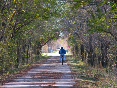
Colorful morning for a ride
Photo by Shelley Grieshop/The Daily Standard

A bicyclist makes his way along the Celina-Coldwater Bike Path near St. Anthony Road on Sunday morning. A high temperature today of 66 will give local residents another chance to enjoy the outdoors before showers move into the Grand Lake area late this evening. Temperatures are expected to plummet the rest of the week.


Additional pictures on this date