Flood Watch issued August 12 at 9:17AM EDT until August 12 at 11:00PM EDT by NWS Wilmington OH (details ...)
* WHAT...Flash flooding caused by excessive rainfall continues to be possible.
* WHERE...Portions of Indiana, including the following counties, Dearborn, Fayette, Franklin, Ohio, Ripley, Switzerland, Union and Wayne, Kentucky, including the following counties, Boone, Bracken, Campbell, Carroll, Gallatin, Grant, Kenton, Lewis, Mason, Owen, Pendleton and Robertson, and Ohio, including the following counties, Adams, Auglaize, Brown, Butler, Champaign, Clark, Clermont, Clinton, Darke, Delaware, Fairfield, Fayette, Franklin, Greene, Hamilton, Hardin, Highland, Hocking, Licking, Logan, Madison, Mercer, Miami, Montgomery, Pickaway, Pike, Preble, Ross, Scioto, Shelby, Union and Warren.
* WHEN...Through this evening.
* IMPACTS...Excessive runoff may result in flooding of rivers, creeks, streams, and other low-lying and flood-prone locations.
* ADDITIONAL DETAILS... - Additional thunderstorms are expected into this evening. Locally heavy rainfall and the potential for storms to repeatedly track over the same areas are possible. This will result in the potential for flash flooding.
Today 83° Today 83° likely 68° 68° slight chance chance Tomorrow 81° Tomorrow 81° chance chance 68° 68° chance
Friday, November 24th, 2006
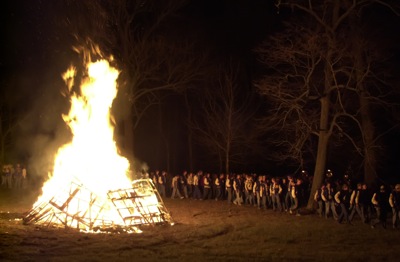
Marion team getting fired up
Photo by Mark Pummell/The Daily Standard

Marion Local football players gather around a large bon fire created for a community pep rally held Wednesday night in the Ron Bruns' woods along Mercer-Auglaize County Line Road. The team plays in the Division VI state semi-final game at 7:30 p.m. tonight against Norwalk-St. Paul.


Additional pictures on this date