Special Weather Statement issued May 18 at 4:44PM EDT by NWS Wilmington OH (details ...)
At 444 PM EDT, strong thunderstorms were located along a line extending from near Spencerville In Allen County to near Union City, moving east at 30 mph.
HAZARD...Wind gusts up to 50 mph, pea size hail, frequent cloud-to-ground lightning, and very heavy rain.
SOURCE...Radar indicated.
IMPACT...Gusty winds could knock down tree limbs and blow around unsecured objects. Hail may cause minor damage to vegetation. Lightning can cause serious injury or death. Visibility will be poor and hydroplaning is possible.
Locations impacted include... Greenville, Celina, Wapakoneta, St. Marys, Coldwater, Fort Shawnee, New Bremen, St. Henry, Cridersville, Union City, Ansonia, New Knoxville, Moulton, Wayne Lakes, Mendon, Chickasaw, Burkettsville, North Star, Buckland, and Rossburg.
This includes I-75 in Ohio between mile markers 114 and 118.
If outdoors, consider seeking shelter inside a sturdy building.
Motorists should slow down and use extra caution.
When thunder roars, go indoors! Do not stay in the open or seek shelter under trees when lightning threatens.
A Severe Thunderstorm Watch remains in effect until 600 PM EDT for west central Ohio.
To report hazardous weather conditions, go to our website at weather.gov/iln and submit your report via social media, when you can do so safely.
Special Weather Statement issued May 18 at 4:38PM EDT by NWS Wilmington OH (details ...)
At 438 PM EDT, strong thunderstorms were located along a line extending from 7 miles west of Fort Loramie to near Greenville, moving northeast at 40 mph.
HAZARD...Wind gusts up to 40 mph and pea size hail.
SOURCE...Radar indicated.
IMPACT...Gusty winds could knock down tree limbs and blow around unsecured objects. Hail may cause minor damage to vegetation.
Locations impacted include... Greenville, Wapakoneta, New Bremen, Minster, Versailles, Newport, Bradford, Fort Loramie, New Knoxville, Webster, Wayne Lakes, Russia, Gettysburg, Osgood, North Star, Kettlersville, Yorkshire, Egypt, Darke County Airport, and State Route 47 at US Route 127.
If outdoors, consider seeking shelter inside a sturdy building.
A Severe Thunderstorm Watch remains in effect until 600 PM EDT for west central Ohio.
To report hazardous weather conditions, go to our website at weather.gov/iln and submit your report via social media, when you can do so safely.
Severe Thunderstorm Watch issued May 18 at 11:11AM EDT until May 18 at 6:00PM EDT by NWS Wilmington OH (details ...)
THE NATIONAL WEATHER SERVICE HAS ISSUED SEVERE THUNDERSTORM WATCH 220 IN EFFECT UNTIL 6 PM EDT THIS EVENING FOR THE FOLLOWING AREAS
IN OHIO THIS WATCH INCLUDES 2 COUNTIES
IN WEST CENTRAL OHIO
AUGLAIZE MERCER
THIS INCLUDES THE CITIES OF CELINA, COLDWATER, MINSTER, NEW BREMEN, ST. MARYS, AND WAPAKONETA.
Today 87° Today 87° chance 68° 68° chance Tomorrow 87° Tomorrow 87° likely 59° 59°
Thursday, March 8th, 2007
Crash at the lighthouse
Photo by Margie Wuebker/The Daily Standard

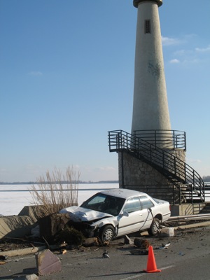
A heavily damaged car sets amid debris near the lighthouse on South Main Street in Celina Wednesday afternoon. Karry A. Roberts Jr., 16, 14506 Coble Road, Yorkshire, was driving north in the 500 block of South Main Street when his car traveled off the right side of the road struck a power pole, decorative wood pillars and a large cement planter. Pieces of wood and concrete were thrown 45 to 50 feet upon impact and electric wires were downed. Roberts was taken by ambulance to Mercer County Community Hospital in Coldwater, where he was treated then released. He was cited for failure to control and the car was towed from the scene. Nearly a dozen motorists received warnings after they drove around marked cruisers and found themselves in the midst of the accident scene potentially putting the lives of emergency personnel and electric department employees in jeopardy.

Additional pictures on this date