Tornado Watch issued May 7 at 6:01PM EDT until May 8 at 1:00AM EDT by NWS Wilmington OH (details ...)
THE NATIONAL WEATHER SERVICE HAS ISSUED TORNADO WATCH 197 IN EFFECT UNTIL 1 AM EDT WEDNESDAY FOR THE FOLLOWING AREAS
IN INDIANA THIS WATCH INCLUDES 8 COUNTIES
IN EAST CENTRAL INDIANA
FAYETTE UNION WAYNE
IN SOUTHEAST INDIANA
DEARBORN FRANKLIN OHIO RIPLEY SWITZERLAND
IN KENTUCKY THIS WATCH INCLUDES 12 COUNTIES
IN NORTHEAST KENTUCKY
LEWIS
IN NORTHERN KENTUCKY
BOONE BRACKEN CAMPBELL CARROLL GALLATIN GRANT KENTON MASON OWEN PENDLETON ROBERTSON
IN OHIO THIS WATCH INCLUDES 32 COUNTIES
IN CENTRAL OHIO
DELAWARE FAIRFIELD FAYETTE FRANKLIN HOCKING LICKING MADISON PICKAWAY UNION
IN SOUTH CENTRAL OHIO
ADAMS HIGHLAND PIKE ROSS SCIOTO
IN SOUTHWEST OHIO
BROWN BUTLER CLERMONT CLINTON HAMILTON WARREN
IN WEST CENTRAL OHIO
AUGLAIZE CHAMPAIGN CLARK DARKE GREENE HARDIN LOGAN MERCER MIAMI MONTGOMERY PREBLE SHELBY
THIS INCLUDES THE CITIES OF ABERDEEN, ADA, ALEXANDRIA, AUGUSTA, AURORA, BATESVILLE, BEAVERCREEK, BELLEFONTAINE, BELLEVUE, BLANCHESTER, BRIGHT, BROOKSVILLE, BROOKVILLE, BURLINGTON, BUTLER, CAMDEN, CAMP DIX, CARROLLTON, CELINA, CHILLICOTHE, CIRCLEVILLE, COLDWATER, CONNERSVILLE, COVINGTON, CRITTENDEN, DAY HEIGHTS, DAYTON, DELAWARE, DILLSBORO, DOWNTOWN CINCINNATI, DOWNTOWN COLUMBUS, DOWNTOWN DAYTON, DRY RIDGE, EATON, ERLANGER, FAIRBORN, FAIRFIELD, FALMOUTH, FLORENCE, FORT THOMAS, FRANKLIN, GEORGETOWN, GREENDALE, GREENFIELD, GREENVILLE, HAMILTON, HEAD OF GRASSY, HIDDEN VALLEY, HIGHLAND HEIGHTS, HILLSBORO, INDEPENDENCE, KENTON, KETTERING, LANCASTER, LANDEN, LAWRENCEBURG, LEBANON, LIBERTY, LOGAN, LONDON, MANCHESTER, MARYSVILLE, MASON, MAYSVILLE, MIDDLETOWN, MILAN, MILFORD, MINSTER, MOUNT CARMEL, MOUNT OLIVET, MOUNT ORAB, MOUNT REPOSE, MULBERRY, NEW BREMEN, NEWARK, NEWPORT, OAKBROOK, OSGOOD, OWENTON, OXFORD, PEEBLES, PICKERINGTON, PIKE LAKE, PIKETON, PIQUA, PLAIN CITY, PORTSMOUTH, RICHMOND, RIPLEY, RISING SUN, SEAMAN, SIDNEY, SPRINGBORO, SPRINGFIELD, ST. MARYS, SUMMERSIDE, TIPP CITY, TOLLESBORO, TROY, URBANA, VANCEBURG, VERSAILLES, VEVAY, WAPAKONETA, WARSAW, WASHINGTON COURT HOUSE, WAVERLY, WEST COLLEGE CORNER, WEST JEFFERSON, WEST UNION, WHEELERSBURG, WILLIAMSTOWN, WILMINGTON, WINCHESTER, WITHAMSVILLE, AND XENIA.
Tornado Warning issued May 7 at 8:39PM EDT until May 7 at 9:00PM EDT by NWS Wilmington OH (details ...)
At 837 PM EDT, radar indicated that a tornado-producing storm was located over New Knoxville, moving east at 45 mph.
HAZARD...Damaging tornado.
SOURCE...Weather spotters confirmed tornado. At 8:35 PM, a tornado was reported just west of New Knoxville.
IMPACT...Flying debris will be dangerous to those caught without shelter. Mobile homes will be damaged or destroyed. Damage to roofs, windows, and vehicles will occur. Tree damage is likely.
Locations impacted include... Wapakoneta, Fort Shawnee, Cridersville, Botkins, Lakeview, New Knoxville, Waynesfield, Moulton, Uniopolis, Fryburg, New Hampshire, and St. Johns.
This includes I-75 in Ohio between mile markers 106 and 118.
59° 59° likely Wed 80° Wed 80° 57° 57° Thu 64° Thu 64°
Tuesday, December 18th, 2007
Photo by Nancy Allen/The Daily Standard

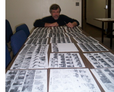
Christopher Gibbs, executive director of the Mercer County Farm Service Agency, studies photos taken of farming activities in Shelby County to determine which ones to include in a presentation set in March. The event, called Images from the Land, will involve images from farm life projected on a huge screen set to music performed by the 35-member Sidney Civic Band. Gibbs is one of many committee members on the Ag in the Arts Committee of the Gateway Arts Council planning the event.

Related online story:
A local ag official is helping plan an event that will combine music and agriculture set to take place in Shelby County in March.
If all goes well, it might be possible to do a similar event here, said Chris Gibbs, executive director of the Mercer County Farm Service Agency. [More]
Additional pictures on this date