Flood Watch issued April 4 at 9:43AM EDT until April 6 at 8:00AM EDT by NWS Wilmington OH (details ...)
* WHAT...Flooding caused by excessive rainfall continues to be possible.
* WHERE...The following counties, in Indiana, Dearborn, Fayette, Franklin, Ohio, Ripley, Switzerland, Union and Wayne, the following counties, in Kentucky, Boone, Bracken, Campbell, Carroll, Gallatin, Grant, Kenton, Lewis, Mason, Owen, Pendleton and Robertson, and the following counties, in Ohio, Adams, Auglaize, Brown, Butler, Champaign, Clark, Clermont, Clinton, Darke, Delaware, Fairfield, Fayette, Franklin, Greene, Hamilton, Hardin, Highland, Hocking, Licking, Logan, Madison, Mercer, Miami, Montgomery, Pickaway, Pike, Preble, Ross, Scioto, Shelby, Union and Warren.
* WHEN...Through Sunday morning.
* IMPACTS...Soils remain moist and excessive runoff may result in flooding of rivers, creeks, streams, and other low-lying and flood-prone locations.
* ADDITIONAL DETAILS... - Multiple rounds of showers and thunderstorms will occur into the weekend with the heaviest rain expected Saturday into Saturday night.
Today 56° Today 56° likely 49° 49° Tomorrow 61° Tomorrow 61° 37° 37°
Friday, February 22nd, 2008
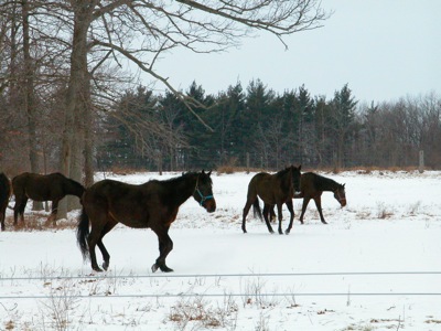
Horse play
Photo by Shelley Grieshop/The Daily Standard

A group of horses wander and kick up an occasional bit of snow in a field in rural Fort Recovery on Thursday. A winter weather advisory remains in effect until 7 p.m. today with light snow, sleet and freezing rain continuing across the area, according to the National Weather Service.

Additional pictures on this date