Flood Watch issued April 3 at 3:52PM EDT until April 6 at 8:00AM EDT by NWS Wilmington OH (details ...)
* WHAT...Flooding caused by excessive rainfall continues to be possible.
* WHERE...The following counties, in Indiana, Dearborn, Fayette, Franklin, Ohio, Ripley, Switzerland, Union and Wayne, the following counties, in Kentucky, Boone, Bracken, Campbell, Carroll, Gallatin, Grant, Kenton, Lewis, Mason, Owen, Pendleton and Robertson, and the following counties, in Ohio, Adams, Auglaize, Brown, Butler, Champaign, Clark, Clermont, Clinton, Darke, Delaware, Fairfield, Fayette, Franklin, Greene, Hamilton, Hardin, Highland, Hocking, Licking, Logan, Madison, Mercer, Miami, Montgomery, Pickaway, Pike, Preble, Ross, Scioto, Shelby, Union and Warren.
* WHEN...Through Sunday morning.
* IMPACTS...Soils remain moist and excessive runoff may result in flooding of rivers, creeks, streams, and other low-lying and flood-prone locations.
* ADDITIONAL DETAILS... - Multiple rounds of rain will occur into the weekend with the heaviest rain expected Saturday into Saturday night.
Today 65° Today 65° slight chance 46° 46° likely Tomorrow 56° Tomorrow 56° 52° 52°
Saturday, February 23rd, 2008
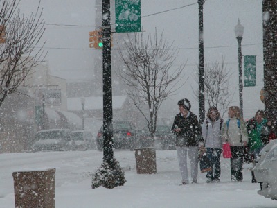
Spring isn't in the air
Photo by Shelley Grieshop/The Daily Standard

Several local residents make their way down the sidewalk near the Coldwater library during a heavy snowfall on Friday afternoon. A winter weather advisory was in effect until midnight Friday. Today's forecast calls for partly cloudy skies with a high 32 and low of 15 overnight, according to local weather forecaster Dennis Howick. No snow is forecasted again until Tuesday.

Additional pictures on this date