Flood Watch issued April 3 at 9:17PM EDT until April 6 at 8:00AM EDT by NWS Wilmington OH (details ...)
* WHAT...Flooding caused by excessive rainfall continues to be possible.
* WHERE...The following counties, in Indiana, Dearborn, Fayette, Franklin, Ohio, Ripley, Switzerland, Union and Wayne, the following counties, in Kentucky, Boone, Bracken, Campbell, Carroll, Gallatin, Grant, Kenton, Lewis, Mason, Owen, Pendleton and Robertson, and the following counties, in Ohio, Adams, Auglaize, Brown, Butler, Champaign, Clark, Clermont, Clinton, Darke, Delaware, Fairfield, Fayette, Franklin, Greene, Hamilton, Hardin, Highland, Hocking, Licking, Logan, Madison, Mercer, Miami, Montgomery, Pickaway, Pike, Preble, Ross, Scioto, Shelby, Union and Warren.
* WHEN...Through Sunday morning.
* IMPACTS...Soils remain moist and excessive runoff may result in flooding of rivers, creeks, streams, and other low-lying and flood-prone locations.
* ADDITIONAL DETAILS... - Multiple rounds of rain will occur into the weekend with the heaviest rain expected Saturday into Saturday night.
46° 46° Fri 58° Fri 58° likely 51° 51° Sat 64° Sat 64°
Wednesday, March 5th, 2008
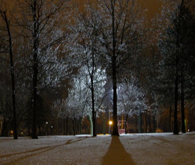
Shimmering ice
Photo by Shelley Grieshop/The Daily Standard

Tree branches coated with ice shimmer in the light from nearby lampposts at Coldwater Memorial Park on Tuesday evening. The Grand Lake area received more than a half inch of rain and sleet and 1.5 inches of snow in the last 24 hours as a result of winter storms that passed through the area. What started out as rain in the morning changed over to a nightmare for drivers early in the afternoon.

Additional pictures on this date