Friday, November 7th, 2008
Local officials working toward connecting trails
By Janie Southard

Photo by Janie Southard/The Daily Standard
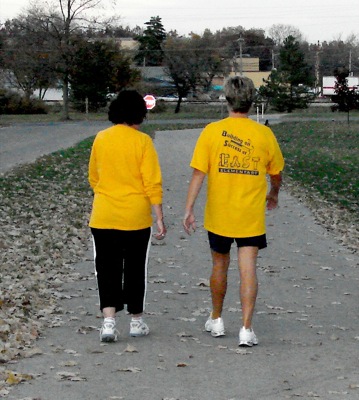
The bike/walking path at East Bank Park in St. Marys is a popular place all year round. Even in winter there are hardy walkers and sometimes even cross country skiers.
MONTEZUMA - The possibility of a nature trail all the way around Grand Lake has got the attention of several area officials and government agencies.
A meeting of local officials Thursday at the Franklin Township House was headed up by Brian Miller, assistant manager of Grand Lake St. Marys State Park, who is a newbie distance cyclist.
Miller began by citing his own enthusiasm for a dedicated bike trail around the lake.
"I'm a big guy and last February I decided if I didn't want to take pills, I'd need to lose weight. So I started riding my bike and after a while I wanted to keep going," he said. "Laura Walker (a GOBA cyclist and local watershed coordinator) told me to just ride around the lake."
That was when it became clear to him that a connected trail around the lake would be a huge asset to the area, especially when he had to ride along portions of the state highway system where there is nothing but berm. When he hit those couple miles of state Route 364 he said he put his head down and "pedaled as fast as I could" in order to get quickly to the nature path through East Bank Park.
It's 27 miles around the lake and that trip takes in a number of townships and municipalities. Therein lies the strength and weakness of this project, according to Ron Puthoff, director of Community Development Services. Puthoff has written grants for many various government bodies over the years.
"There are different funding sources for a project like this. Rather than having every government agency trying to get a piece of the rock and compete against each other, the best way to proceed would be one organization to coordinate the effort," Puthoff said.
The success and popularity of the new 61/2-mile nature trail in Franklin Township has spurred local interest in building more connecting trails, which is one reason ODOT is in support of a Grand Lake Trail System (a working title at this point).
Matt Parrill, an engineer with ODOT in Sidney, said, "(ODOT) would be pleased to be part of this plan ... We can't promise widening any state roads, but we could investigate the possibility of wider shoulders. It would certainly improve (the state's viewpoint) if this project could show unification and phased planning."
Also indicative of the state's interest in nature paths is the newly created office of trails department at the Ohio Department of Natural Resources. This office is currently collecting trail maps statewide in order to establish an Internet site with all Ohio's known nature trails listed and mapped electronically.
Kent Bryan, with the city of Celina, brought plans for the Celina bike path, with the trail head across from the lighthouse where there will be restrooms and parking.
"Construction will begin next spring," he said, also agreeing with Puthoff's comment about a unified project.
Donna Grube of the Auglaize and Mercer Counties Convention & Visitors Bureau, commented that the increase of the past two years in tourists wanting information on local hiking/biking/nature trails has been "incredible."
Puthoff praised Franklin Township for taking a leadership position in building trails.
"I know in the beginning many people were skeptical because something like this is hard to visualize. But you got it done," he said.
What comes next is establishing a group, with one representative from each interested organizations, and looking at the possibilities and feasibility of location. Puthoff said so far there's no way to estimate time frame or cost.
"What we know now is that there is definitely interest," he said.
Also at the meeting were representatives from ODOT; Mercer County Commissioner John Bruns; Franklin Township trustees; Mercer County Economic Development Director Larry Stelzer; Brian May of Fanning/Howey Architects; and Kip Wright of Community Development Services.

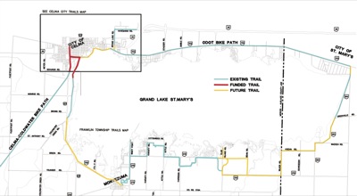
This map shows how bike trails could one day encircle Grand Lake. Existing trails are marked in teal, funded but incomplete trails are red, and future trails are colored gold.
