Flood Watch issued August 15 at 2:16AM EDT until August 16 at 8:00AM EDT by NWS Wilmington OH (details ...)
* WHAT...Flash flooding caused by excessive rainfall continues to be possible.
* WHERE...Portions of Indiana, including the following counties, Fayette, Franklin, Union and Wayne and Ohio, including the following counties, Auglaize, Butler, Champaign, Clark, Clinton, Darke, Delaware, Fairfield, Fayette, Franklin, Greene, Hardin, Hocking, Licking, Logan, Madison, Mercer, Miami, Montgomery, Pickaway, Preble, Ross, Shelby, Union and Warren.
* WHEN...From noon EDT today through Sunday morning.
* IMPACTS...Excessive runoff may result in flooding of rivers, creeks, streams, and other low-lying and flood-prone locations.
* ADDITIONAL DETAILS... - Additional rounds of showers and thunderstorms are expected today and tonight. Heavy rainfall is possible, especially tonight, which may result in flash flooding.
Today 81° Today 81° likely 73° 73° likely Tomorrow 83° Tomorrow 83° chance 70° 70° chance
Friday, January 30th, 2009
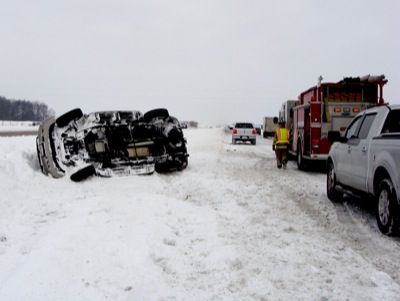
Rollover
Photo by Julie Metz/The Daily Standard

A 2002 GM Envoy rests on its side along state Route 29, east of Riley Road, following an accident at 1:56 p.m. Thursday. Andrea N. Clark, 27, 901 Magnolia St., St. Marys, lost control of the vehicle while driving eastbound in the left lane. The vehicle rotated off the road and overturned. Passing motorists helped Clark and her two young daughters - ages 31/2 and 11/2 - from the wreckage. The Mercer County Sheriff's Office report listed no injuries. A tow truck was called to remove the moderately damaged vehicle. Authorities handled more than 20 reports of disabled vehicles/accidents between 7 a.m. Thursday and 7:40 a.m. today.


Additional pictures on this date