Severe Thunderstorm Warning issued July 3 at 7:07PM EDT until July 3 at 7:45PM EDT by NWS Wilmington OH (details ...)
At 707 PM EDT, a severe thunderstorm was located over St. Marys, moving east at 30 mph. HAZARD...60 mph wind gusts. SOURCE...Radar indicated. IMPACT...Expect damage to trees and power lines. Locations impacted include... Celina, Wapakoneta, St. Marys, Rockford, New Knoxville, Moulton, Mendon, Buckland, Montezuma, Kossuth, Tama, Neptune, and Bulkhead.
Extreme Heat Warning issued July 3 at 11:21AM EDT until July 3 at 8:00PM EDT by NWS Wilmington OH (details ...)
* WHAT...For the Extreme Heat Warning, dangerously hot conditions with heat index values around 105 are expected. For the Heat Advisory, heat index values around 100 are expected. * WHERE...Portions of east central and southeast Indiana, northeast and northern Kentucky, and central, south central, southwest, and west central Ohio. * WHEN...For the Extreme Heat Warning, until 8 PM EDT this evening. For the Heat Advisory, from 8 PM this evening to 8 PM EDT Saturday. * IMPACTS...Heat related illnesses increase significantly during extreme heat and high humidity events, particularly for those working or participating in outdoor activities. Hot temperatures and high humidity may cause heat illnesses. * ADDITIONAL DETAILS...Remember, multiple days with excessive heat can have compounding effects.
Heat Advisory issued July 3 at 11:21AM EDT until July 4 at 8:00PM EDT by NWS Wilmington OH (details ...)
* WHAT...For the Extreme Heat Warning, dangerously hot conditions with heat index values around 105 are expected. For the Heat Advisory, heat index values around 100 are expected. * WHERE...Portions of east central and southeast Indiana, northeast and northern Kentucky, and central, south central, southwest, and west central Ohio. * WHEN...For the Extreme Heat Warning, until 8 PM EDT this evening. For the Heat Advisory, from 8 PM this evening to 8 PM EDT Saturday. * IMPACTS...Heat related illnesses increase significantly during extreme heat and high humidity events, particularly for those working or participating in outdoor activities. Hot temperatures and high humidity may cause heat illnesses. * ADDITIONAL DETAILS...Remember, multiple days with excessive heat can have compounding effects.
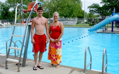
COLDWATER - A tragedy was averted Wednesday afternoon at Memorial Pool in Coldwater following the swift action of two lifeguards.
Nine-year-old Jasmine Adams was not breathing and was unconscious at the bottom of the pool when lifeguard Kristy Schaefer pulled her out of about 5 1/2 feet of water. [More]
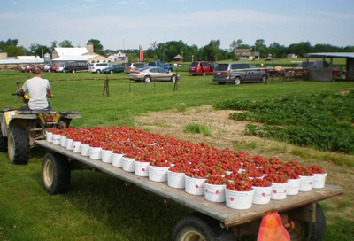
Perfect weather conditions led to an early strawberry harvest and an abundance of the juicy, red fruit at local farms.
Oscar Jutte of Jutte's Fruit Farm & Landscaping in Fort Recovery said this year's bumper crop began to ripen in mid-May - the earliest in more than 20 years. [More]
ST. HENRY - Many residents in St. Henry and Burkettsville erroneously received telephone calls Wednesday night informing them of a tornado warning and the need to take shelter. The notification came as storms rumbled throughout much of the state.
House legislators are acting quickly to get seat belts in school buses following a student's death Wednesday in a bus crash in Muskingum County, 45 miles east of Columbus.
NEW BREMEN - Officials at New Bremen Local Schools will not be receiving a telephone call from the Ohio School Facilities Commission as previously expected.
A Celina man was injured Saturday night when his bicycle was rear-ended by a car in the 3300 block of Mud Pike. The mishap occurred at 6:48 p.m., according to Mercer County Sheriff's Office reports.
MINSTER - Authorities in this Auglaize County community are warning residents to lock their doors before leaving home in the wake of a weekend breaking and entering.
COLUMBUS - Once again there will be a large contingent of Grand Lake area athletes competing at the state track meet at Jesse Owens Stadium in Columbus this weekend.
MINSTER - In kindergarten, Megan Stueve was a visionary.
As she tagged along with her older sister, Erin, to softball practice, she pictured herself one day wearing Orange and Black and hurling softballs for the Minster Wildcats.