Special Weather Statement issued May 1 at 8:06PM EDT by NWS Wilmington OH (details ...)
At 806 PM EDT, a strong thunderstorm was located over Monroe, moving northeast at 35 mph. HAZARD...Wind gusts up to 45 mph and pea size hail. SOURCE...Radar indicated. IMPACT...Gusty winds could knock down tree limbs and blow around unsecured objects. Hail may cause minor damage to vegetation. This storm will remain over mainly rural areas of northwestern Mercer County. If outdoors, consider seeking shelter inside a sturdy building. To report hazardous weather conditions, go to our website at weather.gov/iln and submit your report via social media, when you can do so safely.
Saturday, September 10th, 2011
Re-enactment in Fort Recovery
Photo by Mark Pummell/The Daily Standard
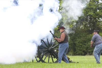
A Civil War re-enactor fires a cannon Friday afternoon during Civil War at the Fort activities. The re-enactment is open to the public today and Sunday at Ambassador Park in Fort Recovery.