Severe Thunderstorm Warning issued April 27 at 11:48PM EDT until April 28 at 12:15AM EDT by NWS Wilmington OH (details ...)
At 1148 PM EDT, severe thunderstorms were located along a line extending from 6 miles east of Geneva to 7 miles south of Winchester, moving east at 60 mph. HAZARD...60 mph wind gusts. SOURCE...Radar indicated. IMPACT...Expect damage to trees and power lines. Locations impacted include... Greenville, Celina, Coldwater, Versailles, St. Henry, Union City, Fort Recovery, Ansonia, Rockford, Webster, Wabash, Mendon, Osgood, Chickasaw, Burkettsville, North Star, Hollansburg, Rossburg, Palestine, and Montezuma.
Severe Thunderstorm Watch issued April 27 at 11:27PM EDT until April 28 at 4:00AM EDT by NWS Wilmington OH (details ...)
SEVERE THUNDERSTORM WATCH 165 REMAINS VALID UNTIL 4 AM EDT TUESDAY FOR THE FOLLOWING AREAS IN INDIANA THIS WATCH INCLUDES 8 COUNTIES IN EAST CENTRAL INDIANA FAYETTE UNION WAYNE IN SOUTHEAST INDIANA DEARBORN FRANKLIN OHIO RIPLEY SWITZERLAND IN KENTUCKY THIS WATCH INCLUDES 10 COUNTIES IN NORTHERN KENTUCKY BOONE BRACKEN CAMPBELL CARROLL GALLATIN GRANT KENTON OWEN PENDLETON ROBERTSON IN OHIO THIS WATCH INCLUDES 6 COUNTIES IN SOUTHWEST OHIO BUTLER CLERMONT HAMILTON IN WEST CENTRAL OHIO DARKE MERCER PREBLE THIS INCLUDES THE CITIES OF ALEXANDRIA, AUGUSTA, AURORA, BATESVILLE, BELLEVUE, BRIGHT, BROOKSVILLE, BROOKVILLE, BURLINGTON, BUTLER, CAMDEN, CARROLLTON, CELINA, COLDWATER, CONNERSVILLE, COVINGTON, CRITTENDEN, DAY HEIGHTS, DAYTON, DILLSBORO, DOWNTOWN CINCINNATI, DRY RIDGE, EATON, ERLANGER, FAIRFIELD, FALMOUTH, FLORENCE, FORT THOMAS, GREENDALE, GREENVILLE, HAMILTON, HIDDEN VALLEY, HIGHLAND HEIGHTS, INDEPENDENCE, LAWRENCEBURG, LIBERTY, MIDDLETOWN, MILAN, MILFORD, MOUNT CARMEL, MOUNT OLIVET, MOUNT REPOSE, MULBERRY, NEWPORT, OAKBROOK, OSGOOD, OWENTON, OXFORD, RICHMOND, RISING SUN, SUMMERSIDE, VERSAILLES, VEVAY, WARSAW, WEST COLLEGE CORNER, WILLIAMSTOWN, AND WITHAMSVILLE.
Special Weather Statement issued April 27 at 11:00PM EDT by NWS Wilmington OH (details ...)
Wind gusts of 35 to 50 MPH will be possible over the next few hours. These winds will occur separately from any thunderstorms. Winds of this magnitude may damage small tree limbs and make driving difficult, especially for high profile vehicles.
Severe Thunderstorm Warning issued April 27 at 11:56PM EDT until April 28 at 1:00AM EDT by NWS Wilmington OH (details ...)
SVRILN The National Weather Service in Wilmington has issued a * Severe Thunderstorm Warning for... Eastern Wayne County in east central Indiana... Western Shelby County in west central Ohio... Northern Preble County in west central Ohio... Darke County in west central Ohio... Northwestern Montgomery County in west central Ohio... Southwestern Auglaize County in west central Ohio... Western Miami County in west central Ohio... * Until 100 AM EDT. * At 1156 PM EDT, severe thunderstorms were located along a line extending from near Winchester to Glenwood, moving east at 50 mph. HAZARD...60 mph wind gusts. SOURCE...Radar indicated. IMPACT...Expect damage to trees and power lines. * Locations impacted include... Richmond, Trotwood, Piqua, Englewood, Greenville, Eaton, West Milton, New Bremen, Minster, Versailles, Covington, Arcanum, Newport, Bradford, Lewisburg, New Paris, Fort Loramie, West Alexandria, Pleasant Hill, and Ansonia. This includes the following Interstates... I-70 in Indiana between mile markers 149 and 156. I-70 in Ohio between mile markers 0 and 26.
Severe Thunderstorm Watch issued April 27 at 11:27PM EDT until April 28 at 4:00AM EDT by NWS Wilmington OH (details ...)
THE NATIONAL WEATHER SERVICE HAS EXTENDED SEVERE THUNDERSTORM WATCH 165 TO INCLUDE THE FOLLOWING AREAS UNTIL 4 AM EDT TUESDAY IN OHIO THIS WATCH INCLUDES 5 COUNTIES IN SOUTHWEST OHIO WARREN IN WEST CENTRAL OHIO AUGLAIZE MIAMI MONTGOMERY SHELBY THIS INCLUDES THE CITIES OF DOWNTOWN DAYTON, FRANKLIN, KETTERING, LANDEN, LEBANON, MASON, MINSTER, NEW BREMEN, PIQUA, SIDNEY, SPRINGBORO, ST. MARYS, TIPP CITY, TROY, AND WAPAKONETA.
Friday, November 2nd, 2012
Photo by Amy Kronenberger/The Daily Standard
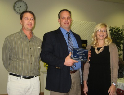
Ed Burtch of Burtch Seed, left, last year's winner of the Rockford Chamber of Commerce Business of the Year award, presents this year's award to administrator Steve Schaaf and director of marketing Leah Hays of the Laurels of Shane Hill and Maplewood of Shane's Village.
ROCKFORD - A local citizen and business were honored for their service to the community during the 39th annual Rockford Chamber of Commerce banquet Thursday. [More]