Severe Thunderstorm Watch issued March 31 at 6:02PM EDT until April 1 at 12:00AM EDT by NWS Wilmington OH (details ...)
THE NATIONAL WEATHER SERVICE HAS ISSUED SEVERE THUNDERSTORM WATCH 82 IN EFFECT UNTIL MIDNIGHT EDT TONIGHT FOR THE FOLLOWING AREAS
IN OHIO THIS WATCH INCLUDES 3 COUNTIES
IN WEST CENTRAL OHIO
AUGLAIZE HARDIN MERCER
THIS INCLUDES THE CITIES OF ADA, CELINA, COLDWATER, KENTON, MINSTER, NEW BREMEN, ST. MARYS, AND WAPAKONETA.
47° 47° chance Wed 57° Wed 57° 44° 44° chance Thu 77° Thu 77° chance slight chance
Tuesday, April 8th, 2014
Submitted Photo

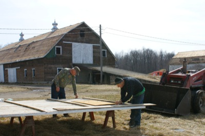
Roger Flaute, left, and Brother Nick Renner last week salvage wood from a structure to be razed on the site of the former Burkettsville novitiate. The bank barn in the background was damaged last year by high winds and is one of the structures to be taken down.

Related online story:
BURKETTSVILLE - A small orchard and aging buildings are all that remain of a once towering religious complex established locally 130 years ago.
The [More]
Additional pictures on this date