Special Weather Statement issued April 19 at 9:54AM EDT by NWS Wilmington OH (details ...)
At 954 AM EDT, a strong thunderstorm was located near Newport, moving east at 55 mph. HAZARD...Wind gusts up to 40 mph and pea size hail. SOURCE...Radar indicated. IMPACT...Gusty winds could knock down tree limbs and blow around unsecured objects. Hail may cause minor damage to vegetation. Locations impacted include... Montra, Newbern, New Jerusalem, Lockington, Ridgeway, Woodstock, Botkins, Mount Victory, Millerstown, Kiser Lake State Park, Hardin, Pemberton, Piqua, West Mansfield, East Liberty, St. Paris, Logansville, Belle Center, North Lewisburg, and Lakeview. This includes I-75 in Ohio between mile markers 77 and 106. If outdoors, consider seeking shelter inside a sturdy building. To report hazardous weather conditions, go to our website at weather.gov/iln and submit your report via social media, when you can do so safely.
CELINA - Council members Monday night unanimously passed legislation authorizing a commercial lease with an option to purchase more than 16 acres of land east of the city for potential water wells to replace Grand Lake as a main drinking water source. [More]
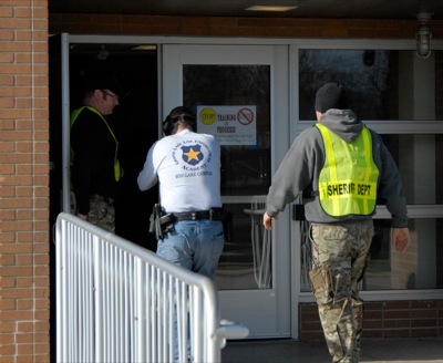
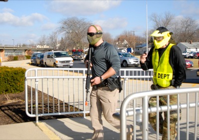
ST. MARYS - Law enforcement officers with guns drawn breached the doors of the intermediate school after receiving a report of shots fired in the halls.
COLDWATER - The opening night of the Asset Allocation Associates Holiday Classic saw one team come back from being down double digits and another team fend off a challenge.
Marion Local jumped out to a 21-4 lead in the first quarter and dominated their opening game of the TSC Holiday Tournament in Wapakoneta with a 62-14 win over Perry on Monday night.