Severe Thunderstorm Warning issued August 10 at 9:49PM EDT until August 10 at 10:30PM EDT by NWS Wilmington OH (details ...)
SVRILN The National Weather Service in Wilmington has issued a * Severe Thunderstorm Warning for... Northeastern Shelby County in west central Ohio... Southern Auglaize County in west central Ohio... Central Mercer County in west central Ohio... * Until 1030 PM EDT. * At 948 PM EDT, a severe thunderstorm was located near St. Marys, moving southeast at 45 mph. HAZARD...60 mph wind gusts and quarter size hail. SOURCE...Radar indicated. IMPACT...Minor hail damage to vehicles is possible. Expect wind damage to trees and power lines. * Locations impacted include... Celina, Wapakoneta, St. Marys, Coldwater, New Bremen, Minster, Anna, Jackson Center, Botkins, New Knoxville, Moulton, Wabash, Port Jefferson, Kettlersville, Montezuma, Fryburg, Montra, Tama, Neptune, and Maplewood. This includes I-75 in Ohio between mile markers 96 and 112.
Severe Thunderstorm Warning issued August 10 at 9:29PM EDT until August 10 at 10:15PM EDT by NWS Wilmington OH (details ...)
SVRILN The National Weather Service in Wilmington has issued a * Severe Thunderstorm Warning for... Northwestern Auglaize County in west central Ohio... Northern Mercer County in west central Ohio... * Until 1015 PM EDT. * At 929 PM EDT, a severe thunderstorm was located near Ohio City, moving east at 35 mph. HAZARD...60 mph wind gusts and quarter size hail. SOURCE...Radar indicated. IMPACT...Minor hail damage to vehicles is possible. Expect wind damage to trees and power lines. * Locations impacted include... Wapakoneta, Fort Shawnee, Cridersville, Rockford, Mendon, Buckland, Uniopolis, Chattanooga, Kossuth, Tama, St. Johns, Neptune, and State Route 116 at State Route 197. This includes I-75 in Ohio between mile markers 111 and 118.
Severe Thunderstorm Watch issued August 10 at 7:26PM EDT until August 11 at 2:00AM EDT by NWS Wilmington OH (details ...)
THE NATIONAL WEATHER SERVICE HAS ISSUED SEVERE THUNDERSTORM WATCH 560 IN EFFECT UNTIL 2 AM EDT TUESDAY FOR THE FOLLOWING AREAS IN INDIANA THIS WATCH INCLUDES 1 COUNTY IN EAST CENTRAL INDIANA WAYNE IN OHIO THIS WATCH INCLUDES 21 COUNTIES IN CENTRAL OHIO DELAWARE FAIRFIELD FAYETTE FRANKLIN HOCKING LICKING MADISON PICKAWAY UNION IN WEST CENTRAL OHIO AUGLAIZE CHAMPAIGN CLARK DARKE GREENE HARDIN LOGAN MERCER MIAMI MONTGOMERY PREBLE SHELBY THIS INCLUDES THE CITIES OF ADA, BEAVERCREEK, BELLEFONTAINE, CAMDEN, CELINA, CIRCLEVILLE, COLDWATER, DELAWARE, DOWNTOWN COLUMBUS, DOWNTOWN DAYTON, EATON, FAIRBORN, GREENVILLE, KENTON, KETTERING, LANCASTER, LOGAN, LONDON, MARYSVILLE, MINSTER, NEW BREMEN, NEWARK, PICKERINGTON, PIQUA, PLAIN CITY, RICHMOND, SIDNEY, SPRINGFIELD, ST. MARYS, TIPP CITY, TROY, URBANA, WAPAKONETA, WASHINGTON COURT HOUSE, WEST JEFFERSON, AND XENIA.
Flood Watch issued August 10 at 1:04PM EDT until August 12 at 8:00AM EDT by NWS Wilmington OH (details ...)
* WHAT...Flash flooding caused by excessive rainfall is possible. * WHERE...Portions of Indiana, including the following counties, Dearborn, Fayette, Franklin, Union and Wayne, Kentucky, including the following counties, Boone, Bracken, Campbell, Kenton, Lewis, Mason, Pendleton and Robertson, and Ohio, including the following counties, Adams, Auglaize, Brown, Butler, Champaign, Clark, Clermont, Clinton, Darke, Delaware, Fairfield, Fayette, Franklin, Greene, Hamilton, Hardin, Highland, Hocking, Licking, Logan, Madison, Mercer, Miami, Montgomery, Pickaway, Pike, Preble, Ross, Scioto, Shelby, Union and Warren. * WHEN...Through Wednesday morning. * IMPACTS...Excessive runoff may result in flooding of rivers, creeks, streams, and other low-lying and flood-prone locations. * ADDITIONAL DETAILS... - Several rounds of thunderstorms are expected through Tuesday night. Locally heavy rainfall can be expected with the potential for storms to repeatedly track over the same locations. This will result in the potential for flash flooding.
CELINA - An emotional custody battle over a local 21-month-old child has gone to the Ohio Supreme Court.
The case involves local residents and certified foster family Brian and Kelly Anderson. The child involved was placed with the Andersons 13 days after birth as a foster child, Brian Anderson said. He explained they were initially told to expect a short-term placement, but after a placement with a relative did not materialize, the child remained in their care. [More]
Seven-run sixth puts New Bremen into district title game
By Colin Foster
WAPAKONETA - The game was within reach for the Minster softball team after an offensive explosion in the top of the sixth inning.
New Bremen quickly put the game out of the reach when they stepped to the plate in the bottom of the frame.
After Minster had scored three times to pull within a run, New Bremen countered with seven runs in the bottom half en route to an 11-3 victory in the Division IV district semifinal on Tuesday at Wapakoneta High School. [More]
Christine H. McDonald (Ley, Bender), age 94 of Celina and formerly of Versailles, Ohio passed peacefully in her home surrounded by her children on May 16, 2016. [More]
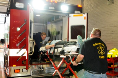
EDITOR'S NOTE: In recognition of Emergency Medical Services Week, the newspaper is publishing a multipart series on local EMS providers over the next few days.
CELINA - A new operations and maintenance plan for septic systems in the county was approved on Tuesday by the Mercer County-Celina City Health Department.
ROCKFORD - Three people will be inducted into the Parkway Academic Alumni Hall of Fame today.
Those being honored are Karen Bollenbacher Casey, James Ripley and Dr. Herbert A. Schumm. They will be admitted during the Parkway High School senior awards program at 7 p.m. in the school auditorium.
ST. MARYS - British author Paul Darlington jokingly said while he speaks a "foreign language," his Manchester, England, hometown and Auglaize County have many similarities - such as canals, for starters.
After having spent over 15 years on the west coast, Bob Moosbrugger is coming home, not only to Northwest Ohio but also to Bowling Green State University.