Cold Weather Advisory issued February 1 at 12:07AM EST until February 1 at 10:00AM EST by NWS Wilmington OH (details ...)
* WHAT...Very cold wind chills as low as 15 below zero. * WHERE...Portions of east central and southeast Indiana, northeast and northern Kentucky, and central, south central, southwest, and west central Ohio. * WHEN...Until 10 AM EST this morning. * IMPACTS...The cold wind chills as low as 15 below zero could result in hypothermia or frostbite if precautions are not taken. Very cold temperatures can lead to hypothermia with prolonged exposure.
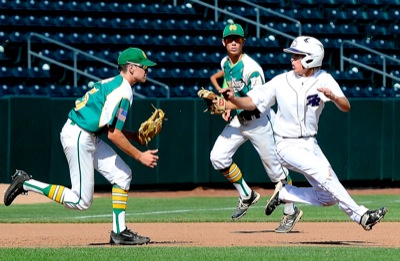
COLUMBUS - The first four innings of Friday's Division IV state baseball semifinal at Huntington Park was a game of "can you top this?"
Fort Recovery took the early lead only to see Newark Catholic tie it up and then take a lead. Fort Recovery then came back to tie the game at 3-3. [More]
CELINA - New legal requirements make planning ahead for immunizations for seventh- and 12th-graders a good idea, Amber Mustard of the Mercer County-Celina City Health Department said.
COLDWATER - Dying ash trees at Coldwater Memorial Park have been transformed into towering sculptures dedicated to the five branches of the U.S. Armed Forces.