Special Weather Statement issued October 21 at 4:34PM EDT by NWS Wilmington OH (details ...)
At 434 PM EDT, strong thunderstorms were located along a line extending from near Delphos to near Versailles, moving east at 40 mph.
HAZARD...Wind gusts up to 45 mph.
SOURCE...Radar indicated.
IMPACT...Gusty winds could knock down tree limbs and blow around unsecured objects.
Locations impacted include... Sidney, Wapakoneta, St. Marys, Ada, Fort Shawnee, New Bremen, Minster, Newport, Cridersville, Anna, Fort Loramie, Jackson Center, Russells Point, De Graff, Botkins, Lakeview, New Knoxville, Alger, Waynesfield, and Chippewa Park.
This includes I-75 in Ohio between mile markers 91 and 118.
If outdoors, consider seeking shelter inside a sturdy building.
To report hazardous weather conditions, go to our website at weather.gov/iln and submit your report via social media, when you can do so safely.
Today 63° Today 63° chance 42° 42° slight chance Tomorrow 54° Tomorrow 54° slight chance 38° 38° slight chance
Monday, November 7th, 2016
Photo by Ed Gebert/The Daily Standard

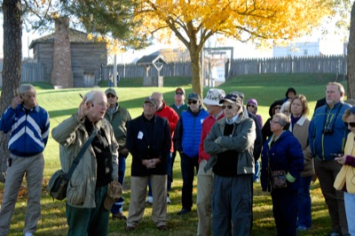
Historian John Winkler makes a point while conducting a walk around the site of the Battle on the Wabash from 1791. Winkler was a featured speaker at the Wabash 1791 Symposium on Saturday in Fort Recovery.

Additional pictures on this date