Severe Thunderstorm Warning issued April 27 at 11:48PM EDT until April 28 at 12:15AM EDT by NWS Wilmington OH (details ...)
At 1148 PM EDT, severe thunderstorms were located along a line extending from 6 miles east of Geneva to 7 miles south of Winchester, moving east at 60 mph. HAZARD...60 mph wind gusts. SOURCE...Radar indicated. IMPACT...Expect damage to trees and power lines. Locations impacted include... Greenville, Celina, Coldwater, Versailles, St. Henry, Union City, Fort Recovery, Ansonia, Rockford, Webster, Wabash, Mendon, Osgood, Chickasaw, Burkettsville, North Star, Hollansburg, Rossburg, Palestine, and Montezuma.
Severe Thunderstorm Watch issued April 27 at 11:27PM EDT until April 28 at 4:00AM EDT by NWS Wilmington OH (details ...)
SEVERE THUNDERSTORM WATCH 165 REMAINS VALID UNTIL 4 AM EDT TUESDAY FOR THE FOLLOWING AREAS IN INDIANA THIS WATCH INCLUDES 8 COUNTIES IN EAST CENTRAL INDIANA FAYETTE UNION WAYNE IN SOUTHEAST INDIANA DEARBORN FRANKLIN OHIO RIPLEY SWITZERLAND IN KENTUCKY THIS WATCH INCLUDES 10 COUNTIES IN NORTHERN KENTUCKY BOONE BRACKEN CAMPBELL CARROLL GALLATIN GRANT KENTON OWEN PENDLETON ROBERTSON IN OHIO THIS WATCH INCLUDES 6 COUNTIES IN SOUTHWEST OHIO BUTLER CLERMONT HAMILTON IN WEST CENTRAL OHIO DARKE MERCER PREBLE THIS INCLUDES THE CITIES OF ALEXANDRIA, AUGUSTA, AURORA, BATESVILLE, BELLEVUE, BRIGHT, BROOKSVILLE, BROOKVILLE, BURLINGTON, BUTLER, CAMDEN, CARROLLTON, CELINA, COLDWATER, CONNERSVILLE, COVINGTON, CRITTENDEN, DAY HEIGHTS, DAYTON, DILLSBORO, DOWNTOWN CINCINNATI, DRY RIDGE, EATON, ERLANGER, FAIRFIELD, FALMOUTH, FLORENCE, FORT THOMAS, GREENDALE, GREENVILLE, HAMILTON, HIDDEN VALLEY, HIGHLAND HEIGHTS, INDEPENDENCE, LAWRENCEBURG, LIBERTY, MIDDLETOWN, MILAN, MILFORD, MOUNT CARMEL, MOUNT OLIVET, MOUNT REPOSE, MULBERRY, NEWPORT, OAKBROOK, OSGOOD, OWENTON, OXFORD, RICHMOND, RISING SUN, SUMMERSIDE, VERSAILLES, VEVAY, WARSAW, WEST COLLEGE CORNER, WILLIAMSTOWN, AND WITHAMSVILLE.
Special Weather Statement issued April 27 at 11:00PM EDT by NWS Wilmington OH (details ...)
Wind gusts of 35 to 50 MPH will be possible over the next few hours. These winds will occur separately from any thunderstorms. Winds of this magnitude may damage small tree limbs and make driving difficult, especially for high profile vehicles.
Severe Thunderstorm Warning issued April 27 at 11:56PM EDT until April 28 at 1:00AM EDT by NWS Wilmington OH (details ...)
SVRILN The National Weather Service in Wilmington has issued a * Severe Thunderstorm Warning for... Eastern Wayne County in east central Indiana... Western Shelby County in west central Ohio... Northern Preble County in west central Ohio... Darke County in west central Ohio... Northwestern Montgomery County in west central Ohio... Southwestern Auglaize County in west central Ohio... Western Miami County in west central Ohio... * Until 100 AM EDT. * At 1156 PM EDT, severe thunderstorms were located along a line extending from near Winchester to Glenwood, moving east at 50 mph. HAZARD...60 mph wind gusts. SOURCE...Radar indicated. IMPACT...Expect damage to trees and power lines. * Locations impacted include... Richmond, Trotwood, Piqua, Englewood, Greenville, Eaton, West Milton, New Bremen, Minster, Versailles, Covington, Arcanum, Newport, Bradford, Lewisburg, New Paris, Fort Loramie, West Alexandria, Pleasant Hill, and Ansonia. This includes the following Interstates... I-70 in Indiana between mile markers 149 and 156. I-70 in Ohio between mile markers 0 and 26.
Severe Thunderstorm Watch issued April 27 at 11:27PM EDT until April 28 at 4:00AM EDT by NWS Wilmington OH (details ...)
THE NATIONAL WEATHER SERVICE HAS EXTENDED SEVERE THUNDERSTORM WATCH 165 TO INCLUDE THE FOLLOWING AREAS UNTIL 4 AM EDT TUESDAY IN OHIO THIS WATCH INCLUDES 5 COUNTIES IN SOUTHWEST OHIO WARREN IN WEST CENTRAL OHIO AUGLAIZE MIAMI MONTGOMERY SHELBY THIS INCLUDES THE CITIES OF DOWNTOWN DAYTON, FRANKLIN, KETTERING, LANDEN, LEBANON, MASON, MINSTER, NEW BREMEN, PIQUA, SIDNEY, SPRINGBORO, ST. MARYS, TIPP CITY, TROY, AND WAPAKONETA.
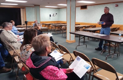
COLDWATER - Nobody wants to talk about suicide, but it's a serious local and national problem, a local expert said.
Brian Engle, executive director of Foundations Behavioral Health Services, spoke Tuesday at Holy Trinity Church about the causes of suicidal thoughts. He encouraged people to intervene if they see someone exhibiting the symptoms. [More]
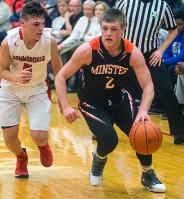
WAPAKONETA - Fort Recovery has waited a year for another shot at Perry.
The wait is over on Friday.
With a 48-34 victory over St. Henry in Tuesday's Division IV district semifinal, the Indians advanced to face the Commodores, who defeated Minster 62-50 in Tuesday's opening game at Wapakoneta. The teams will return to the same site for a 7 p.m. tip-off on Friday evening. [More]
CELINA - The Mercer County Fair is celebrating its 165th anniversary this year.
Board members are planning exhibits and asking the community to share historical memorabilia, including photographs, old fair books and articles to display during the fair, Aug. 11-17.
ST. HENRY - W.G. Dairy Supply President Tony Stoller said his business has moved from its longtime Minster site to 5961 state Route 119, St. Henry, for two reasons.
Minster enters familiar territory and faces one familiar foe with the chance to face yet another when the Wildcats play in the Division IV regional semifinals on Thursday night in Vandalia.