Special Weather Statement issued July 27 at 12:36PM EDT by NWS Wilmington OH (details ...)
At 1236 PM EDT, a strong thunderstorm was located near St. Marys, moving southeast at 25 mph.
HAZARD...Wind gusts up to 50 mph.
SOURCE...Radar indicated.
IMPACT...Gusty winds could knock down tree limbs and blow around unsecured objects.
Locations impacted include... St. Marys, New Bremen, Minster, Newport, Anna, Fort Loramie, Botkins, New Knoxville, Moulton, Chickasaw, Kettlersville, Montezuma, Egypt, Lake Loramie State Park, Maria Stein, Carthagena, Bulkhead, Mccartyville, and Houston.
This includes I-75 in Ohio between mile markers 101 and 107.
If outdoors, consider seeking shelter inside a sturdy building.
To report hazardous weather conditions, go to our website at weather.gov/iln and submit your report via social media, when you can do so safely.
Today 86° Today 86° likely 75° 75° chance Tomorrow 89° Tomorrow 89° slight chance 76° 76° slight chance
Saturday, August 19th, 2017
Accident investigated
Photo by Amy Kronenberger/The Daily Standard

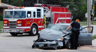
Celina police officers, with the help from members of the Celina fire department and EMS, investigate a minor injury accident on Friday afternoon at the intersection of Walnut and Wayne streets. The crash occurred at 1:27 p.m. No one was transported from the scene by EMS.

Additional pictures on this date