Severe Thunderstorm Warning issued March 26 at 8:27PM EDT until March 26 at 9:15PM EDT by NWS Wilmington OH (details ...)
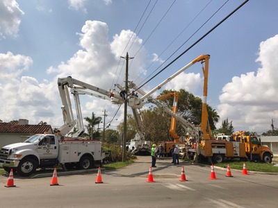
SVRILN The National Weather Service in Wilmington has issued a * Severe Thunderstorm Warning for... Shelby County in west central Ohio... Southwestern Logan County in west central Ohio... Northeastern Darke County in west central Ohio... Southwestern Auglaize County in west central Ohio... Southeastern Mercer County in west central Ohio... * Until 915 PM EDT. * At 827 PM EDT, a severe thunderstorm was located over New Bremen, moving east at 45 mph. HAZARD...Golf ball size hail and 60 mph wind gusts. SOURCE...Radar indicated. IMPACT...People and animals outdoors will be injured. Expect hail damage to roofs, siding, windows, and vehicles. Expect wind damage to trees and power lines. * Locations impacted include... Sidney, New Bremen, Minster, Newport, Anna, Fort Loramie, Jackson Center, De Graff, Botkins, New Knoxville, Hardin, Quincy, Russia, Port Jefferson, Osgood, Kettlersville, Lockington, Yorkshire, Montra, and Newbern.
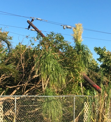
Tornado Warning issued March 26 at 8:23PM EDT until March 26 at 8:45PM EDT by NWS Wilmington OH (details ...)
At 823 PM EDT, a severe thunderstorm capable of producing a tornado was located near New Bremen, moving east at 45 mph. HAZARD...Tornado and golf ball size hail. SOURCE...Radar indicated rotation. IMPACT...Flying debris will be dangerous to those caught without shelter. Mobile homes will be damaged or destroyed. Damage to roofs, windows, and vehicles will occur. Tree damage is likely. Locations impacted include... New Bremen, Minster, Newport, Fort Loramie, Osgood, Chickasaw, Kettlersville, Montezuma, Yorkshire, Egypt, Lake Loramie State Park, Maria Stein, and Carthagena.
Tornado Watch issued March 26 at 7:37PM EDT until March 26 at 11:00PM EDT by NWS Wilmington OH (details ...)
TORNADO WATCH 75 REMAINS VALID UNTIL 11 PM EDT THIS EVENING FOR THE FOLLOWING AREAS IN OHIO THIS WATCH INCLUDES 8 COUNTIES IN CENTRAL OHIO DELAWARE LICKING UNION OH IN WEST CENTRAL OHIO AUGLAIZE HARDIN LOGAN MERCER SHELBY THIS INCLUDES THE CITIES OF ADA, BELLEFONTAINE, CELINA, COLDWATER, DELAWARE, KENTON, MARYSVILLE, NEWARK, SIDNEY, ST. MARYS, AND WAPAKONETA.
Severe Thunderstorm Warning issued March 26 at 8:18PM EDT until March 26 at 9:00PM EDT by NWS Wilmington OH (details ...)
SVRILN The National Weather Service in Wilmington has issued a * Severe Thunderstorm Warning for... Northeastern Shelby County in west central Ohio... Northern Logan County in west central Ohio... Northwestern Union County in central Ohio... Hardin County in west central Ohio... Auglaize County in west central Ohio... * Until 900 PM EDT. * At 818 PM EDT, severe thunderstorms were located along a line extending from near Upper Sandusky to near Kenton to St. Marys, moving east at 50 mph. HAZARD...60 mph wind gusts and quarter size hail. SOURCE...Radar indicated. IMPACT...Minor hail damage to vehicles is possible. Expect wind damage to trees and power lines. * Locations impacted include... Wapakoneta, St. Marys, Kenton, Ada, Cridersville, Jackson Center, Forest, Russells Point, Botkins, Lakeview, New Knoxville, Dunkirk, Alger, Waynesfield, Belle Center, Chippewa Park, Northwood, Moulton, Blanchard, and Roundhead.
Wednesday, September 27th, 2017
Photo by Nick Wenning/The Daily Standard
Coldwater's Olivia Harlamert, 5, spikes the ball past the blocking of Celina's Maddy Luebke, 17, and Brooke Robbins during Tuesday's Mercer County volleyball contest at the Palace. Coldwater swept the match in three sets to improve to 16-0.