Special Weather Statement issued May 1 at 8:06PM EDT by NWS Wilmington OH (details ...)
At 806 PM EDT, a strong thunderstorm was located over Monroe, moving northeast at 35 mph.
HAZARD...Wind gusts up to 45 mph and pea size hail.
SOURCE...Radar indicated.
IMPACT...Gusty winds could knock down tree limbs and blow around unsecured objects. Hail may cause minor damage to vegetation.
This storm will remain over mainly rural areas of northwestern Mercer County.
If outdoors, consider seeking shelter inside a sturdy building.
To report hazardous weather conditions, go to our website at weather.gov/iln and submit your report via social media, when you can do so safely.
57° 57° likely slight chance Fri 72° Fri 72° chance 53° 53° likely Sat 59° Sat 59° likely
Wednesday, February 7th, 2018
Slide-off crash
Photo by Mark Pummell/The Daily Standard

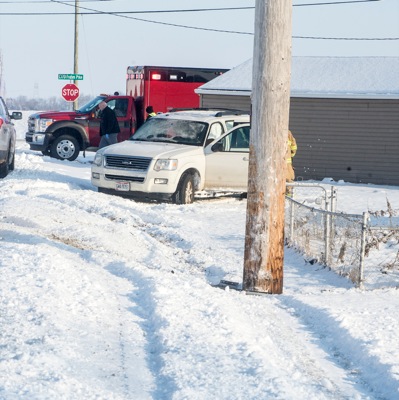
A Ford sport utility vehicle remains at the scene of a Tuesday morning accident on Fleetfoot Road near Frahm Pike near Celina after reportedly sliding into a utility pole. Four children in addition to the driver were reportedly inside the vehicle at the time of the accident. No further information was available at press time.

Additional pictures on this date