The Daily Standard
Pictures Archive
Menu
▼
Home
Subscribe
E-Edition
Archives
▼
Archives
Obituary Archives
Photo Albums
Podcasts
▼
Podcasts
Video
Classifieds
▼
Classifieds
Public Notices
Weather
Sports
More
▼
Contacts
Advertising
Subscription Payment
Community Pictures
Historical Maps
Forms
Locations
Elections
Today
68°
Today
68°
40°
40°
Tomorrow
62°
Tomorrow
62°
52°
52°
Wednesday, June 6th, 2018
Sports Snapshots: A look at the past week in area sports
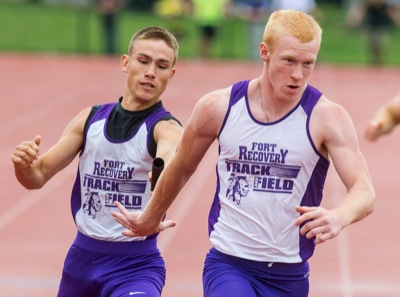
Photo by Daily Standard Staff
Fort Recovery's Jared Timmerman, left, hands the baton to Brayden Schoen.
Purchase a print of this photo.
Archive of June 6th, 2018
Buy this E-Edition
Additional pictures on this date
<!--Unsupported browser-->
Copyright © 2026 Standard Printing Co. All Rights Reserved