Severe Thunderstorm Warning issued August 10 at 10:07PM EDT until August 10 at 10:30PM EDT by NWS Wilmington OH (details ...)
At 1007 PM EDT, a severe thunderstorm was located near Wapakoneta, moving southeast at 40 mph. HAZARD...60 mph wind gusts and quarter size hail. SOURCE...Radar indicated. IMPACT...Minor hail damage to vehicles is possible. Expect wind damage to trees and power lines. Locations impacted include... Celina, Wapakoneta, St. Marys, Coldwater, New Bremen, Minster, Anna, Jackson Center, Botkins, New Knoxville, Moulton, Wabash, Port Jefferson, Kettlersville, Montezuma, Fryburg, Montra, Tama, Neptune, and Maplewood. This includes I-75 in Ohio between mile markers 96 and 112.
Severe Thunderstorm Watch issued August 10 at 7:26PM EDT until August 11 at 2:00AM EDT by NWS Wilmington OH (details ...)
THE NATIONAL WEATHER SERVICE HAS ISSUED SEVERE THUNDERSTORM WATCH 560 IN EFFECT UNTIL 2 AM EDT TUESDAY FOR THE FOLLOWING AREAS IN INDIANA THIS WATCH INCLUDES 1 COUNTY IN EAST CENTRAL INDIANA WAYNE IN OHIO THIS WATCH INCLUDES 21 COUNTIES IN CENTRAL OHIO DELAWARE FAIRFIELD FAYETTE FRANKLIN HOCKING LICKING MADISON PICKAWAY UNION IN WEST CENTRAL OHIO AUGLAIZE CHAMPAIGN CLARK DARKE GREENE HARDIN LOGAN MERCER MIAMI MONTGOMERY PREBLE SHELBY THIS INCLUDES THE CITIES OF ADA, BEAVERCREEK, BELLEFONTAINE, CAMDEN, CELINA, CIRCLEVILLE, COLDWATER, DELAWARE, DOWNTOWN COLUMBUS, DOWNTOWN DAYTON, EATON, FAIRBORN, GREENVILLE, KENTON, KETTERING, LANCASTER, LOGAN, LONDON, MARYSVILLE, MINSTER, NEW BREMEN, NEWARK, PICKERINGTON, PIQUA, PLAIN CITY, RICHMOND, SIDNEY, SPRINGFIELD, ST. MARYS, TIPP CITY, TROY, URBANA, WAPAKONETA, WASHINGTON COURT HOUSE, WEST JEFFERSON, AND XENIA.
Flood Watch issued August 10 at 1:04PM EDT until August 12 at 8:00AM EDT by NWS Wilmington OH (details ...)
* WHAT...Flash flooding caused by excessive rainfall is possible. * WHERE...Portions of Indiana, including the following counties, Dearborn, Fayette, Franklin, Union and Wayne, Kentucky, including the following counties, Boone, Bracken, Campbell, Kenton, Lewis, Mason, Pendleton and Robertson, and Ohio, including the following counties, Adams, Auglaize, Brown, Butler, Champaign, Clark, Clermont, Clinton, Darke, Delaware, Fairfield, Fayette, Franklin, Greene, Hamilton, Hardin, Highland, Hocking, Licking, Logan, Madison, Mercer, Miami, Montgomery, Pickaway, Pike, Preble, Ross, Scioto, Shelby, Union and Warren. * WHEN...Through Wednesday morning. * IMPACTS...Excessive runoff may result in flooding of rivers, creeks, streams, and other low-lying and flood-prone locations. * ADDITIONAL DETAILS... - Several rounds of thunderstorms are expected through Tuesday night. Locally heavy rainfall can be expected with the potential for storms to repeatedly track over the same locations. This will result in the potential for flash flooding.
Flood Advisory issued August 10 at 10:15PM EDT until August 11 at 1:15AM EDT by NWS Wilmington OH (details ...)
* WHAT...Flooding caused by excessive rainfall is expected. * WHERE...Northwestern Union County in central Ohio... Northeastern Auglaize County in west central Ohio... Southern Hardin County in west central Ohio... Logan County in west central Ohio... Northeastern Shelby County in west central Ohio... * WHEN...Until 115 AM EDT. * IMPACTS...Minor flooding in low-lying and poor drainage areas. * ADDITIONAL DETAILS... - At 1015 PM EDT, radar indicated heavy rain due to thunderstorms. Minor flooding is ongoing or expected to begin shortly in the advisory area. Between 0.5 and 1.5 inches of rain have fallen. Additional rainfall amounts up to 2.5 inches are possible. - Some locations that may experience flooding include... Bellefontaine, Kenton, West Liberty, Russells Point, De Graff, Lakeview, Waynesfield, Belle Center, West Mansfield, Chippewa Park, Northwood, Roundhead, Quincy, Mount Victory, Rushsylvania, Huntsville, Ridgeway, Valley Hi, Zanesfield and Big Springs.
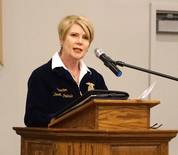
CELINA - Ohio Department of Agriculture officials plan to spend millions of dollars to improve soil testing and nutrient-management plans, according to ODA Director Dorothy Pelanda.
Pelanda, the keynote speaker at Tuesday night's Mercer County Republican Party's Reagan Day Dinner, said the challenge that lies ahead for her agency is to use every dollar of an anticipated $30 million allocation to effect positive change that can be measured down the road. [More]
With one big inning, Fort Recovery got its biggest win of the season.
Trailing by one run and down its final six outs, Fort Recovery hung a six-spot on the scoreboard in the sixth inning to stun Minster, 10-5, in MAC play on Tuesday. [More]
CELINA - Mercer County commissioners on Tuesday awarded a $285,244 contract to Braun Excavating of Celina to extend a road and sewer service to a new business planned in the Franklin Industrial Park.
ROCKFORD - Parkway school board members settled a grievance on Tuesday with one of the four employees laid off in June amid budget cuts to stop deficit spending.
WAPAKONETA - People should monitor their alcohol consumption as warmer weather arrives, Auglaize County Medical Director Dr. Juan Torres said at Tuesday's health board meeting.
State considers proposal to change school financing
COLDWATER - Under a proposed state school funding formula, Coldwater Exempted Village Schools could receive an additional $518,418 in fiscal year 2021 compared with what officials currently anticipate, according to district treasurer Michelle Mawer.
COLUMBUS - The committee supporting changing the way Ohio apportions its Electoral College votes for president has withdrawn its proposed amendment, according to a news release from Ohio Secretary of State Frank LaRose.
CELINA - With the flu making its way around the Celina softball dugout, Makenna Ashmore got a chance to bat for the first time this season in Tuesday's game with Kenton.
Rylee Deitsch scattered three hits and a walk over five innings and added three hits and two RBIs in the Redskin' 11-0 win over Marion Local in five innings in MAC play at the Airport in Maria Stein.