Special Weather Statement issued April 19 at 9:54AM EDT by NWS Wilmington OH (details ...)
At 954 AM EDT, a strong thunderstorm was located near Newport, moving east at 55 mph. HAZARD...Wind gusts up to 40 mph and pea size hail. SOURCE...Radar indicated. IMPACT...Gusty winds could knock down tree limbs and blow around unsecured objects. Hail may cause minor damage to vegetation. Locations impacted include... Montra, Newbern, New Jerusalem, Lockington, Ridgeway, Woodstock, Botkins, Mount Victory, Millerstown, Kiser Lake State Park, Hardin, Pemberton, Piqua, West Mansfield, East Liberty, St. Paris, Logansville, Belle Center, North Lewisburg, and Lakeview. This includes I-75 in Ohio between mile markers 77 and 106. If outdoors, consider seeking shelter inside a sturdy building. To report hazardous weather conditions, go to our website at weather.gov/iln and submit your report via social media, when you can do so safely.
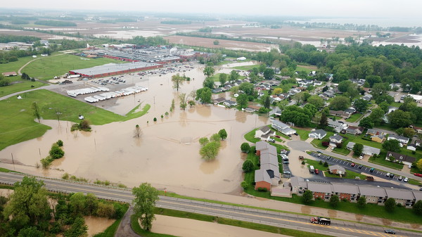
St. MARYS - Heavy rainfall and hail pounded Mercer and Auglaize counties Thursday night into Friday morning, causing extensive flooding and one local school district to close for the day. [More]
CELINA - City officials are still eyeing July 15 to complete the Harley C. Jones Memorial Rotary Amphitheater, the impressive centerpiece of the Bryson Park District along Lake Shore Drive.
Clear Fork jumped out to a 6-1 lead on Celina and held off the Bulldogs late in the game to win 8-4 in a Division II sectional baseball final on Friday at Bellville, located south of Mansfield.