Special Weather Statement issued April 19 at 9:54AM EDT by NWS Wilmington OH (details ...)
At 954 AM EDT, a strong thunderstorm was located near Newport, moving east at 55 mph.
HAZARD...Wind gusts up to 40 mph and pea size hail.
SOURCE...Radar indicated.
IMPACT...Gusty winds could knock down tree limbs and blow around unsecured objects. Hail may cause minor damage to vegetation.
Locations impacted include... Montra, Newbern, New Jerusalem, Lockington, Ridgeway, Woodstock, Botkins, Mount Victory, Millerstown, Kiser Lake State Park, Hardin, Pemberton, Piqua, West Mansfield, East Liberty, St. Paris, Logansville, Belle Center, North Lewisburg, and Lakeview.
This includes I-75 in Ohio between mile markers 77 and 106.
If outdoors, consider seeking shelter inside a sturdy building.
To report hazardous weather conditions, go to our website at weather.gov/iln and submit your report via social media, when you can do so safely.
Today 66° Today 66° 48° 48° chance Tomorrow 64° Tomorrow 64° slight chance 58° 58° chance
Friday, February 7th, 2020
Photo by Leslie Gartrell/The Daily Standard

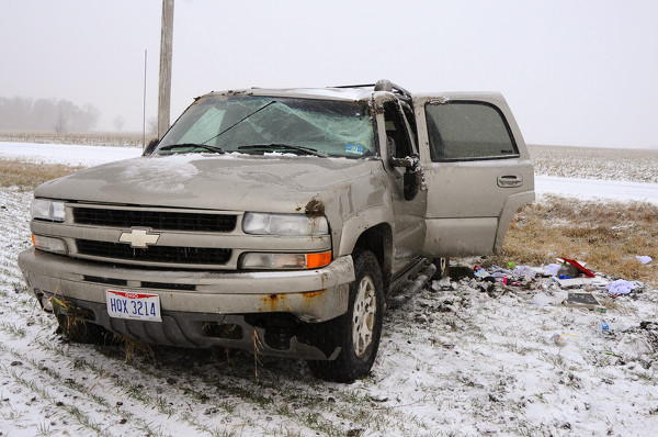
The Mercer County Sheriff's office and Celina Emergency Medical Services personnel responded to a slide-off accident at Hellwarth and Miller roads in Hopewell Township on Thursday afternoon. After hitting a patch of black ice, the vehicle veered off the side of the road and rolled over into a field. The driver and her young daughter were transported with minor injuries by Celina EMS to Mercer County Community Hospital, Coldwater.

Additional pictures on this date