Special Weather Statement issued January 19 at 7:13AM EST by NWS Wilmington OH (details ...)
Snow showers associated with an arctic front are moving through this morning, providing a quick accumulation of snowfall. With wind gusts between 30 and 40 mph, the snow showers combined with blowing snow are reducing visibility and creating challenging travel conditions. These conditions are most impactful on roads that are more rural and are aligned from north to south. Even after the snow ends, elevated winds will continue to blow snow into the early afternoon.
Use caution and allow for extra time to reach your destination.
Special Weather Statement issued January 19 at 4:06AM EST by NWS Wilmington OH (details ...)
An Arctic front will sweep east across the region between 5 AM and 9 AM. A few hours of snow showers and west wind gusts of 35 to 40 mph will occur with the frontal passage. While any accumulations will generally be a half inch or less, some challenging travel conditions may develop given, rapidly changing road conditions and visibilities, strong wind and cold temperatures. These conditions will impact the morning commute. Use caution and allow for extra time to reach your destination.
Cold Weather Advisory issued January 19 at 12:14AM EST until January 20 at 10:00AM EST by NWS Wilmington OH (details ...)
* WHAT...Very cold wind chills as low as 15 below zero expected.
* WHERE...Portions of east central Indiana and central and west central Ohio.
* WHEN...From 7 AM this morning to 10 AM EST Tuesday.
* IMPACTS...The cold wind chills could result in hypothermia if precautions are not taken. Wind chill values can lead to hypothermia with prolonged exposure.
Today 18° Today 18° likely Tomorrow 19° Tomorrow 19° 13° 13°
Wednesday, March 18th, 2020
Photo by Ryan Snyder/The Daily Standard

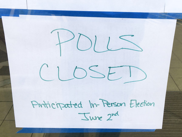
A handwritten sign that polls were closed is taped to a window at the Galleria in Celina Tuesday morning.

Additional pictures on this date