Flood Watch issued April 2 at 3:24AM EDT until April 6 at 8:00AM EDT by NWS Wilmington OH (details ...)
* WHAT...Flooding caused by excessive rainfall continues to be possible.
* WHERE...The following counties, in Indiana, Dearborn, Fayette, Franklin, Ohio, Ripley, Switzerland, Union and Wayne, the following counties, in Kentucky, Boone, Bracken, Campbell, Carroll, Gallatin, Grant, Kenton, Lewis, Mason, Owen, Pendleton and Robertson, and the following counties, in Ohio, Adams, Auglaize, Brown, Butler, Champaign, Clark, Clermont, Clinton, Darke, Delaware, Fairfield, Fayette, Franklin, Greene, Hamilton, Hardin, Highland, Hocking, Licking, Logan, Madison, Mercer, Miami, Montgomery, Pickaway, Pike, Preble, Ross, Scioto, Shelby, Union and Warren.
* WHEN...From this evening through Sunday morning.
* IMPACTS...Soils remain moist and excessive runoff may result in flooding of rivers, creeks, streams, and other low-lying and flood-prone locations.
Wind Advisory issued April 2 at 3:21AM EDT until April 3 at 12:00AM EDT by NWS Wilmington OH (details ...)
* WHAT...South winds 15 to 25 mph with gusts up to 50 mph expected.
* WHERE...Portions of east central and southeast Indiana, northern Kentucky, and southwest and west central Ohio.
* WHEN...From 10 AM this morning to midnight EDT tonight.
* IMPACTS...Gusty winds will blow around unsecured objects. Tree limbs could be blown down and a few power outages may result.
Severe Thunderstorm Warning issued April 2 at 9:37AM EDT until April 2 at 9:45AM EDT by NWS Wilmington OH (details ...)
The storm which prompted the warning has weakened below severe limits and no longer poses an immediate threat to life or property. Therefore, the warning will be allowed to expire. However, small hail is still possible with this thunderstorm.
Please report previous wind damage or hail to the National Weather Service by going to our website at weather.gov/iln and submitting your report via social media.
Special Weather Statement issued April 2 at 9:28AM EDT by NWS Wilmington OH (details ...)
At 928 AM EDT, strong thunderstorms were located along a line extending from near Jackson Center to 7 miles southeast of Sidney, moving northeast at 70 mph.
HAZARD...Wind gusts up to 40 mph and half inch hail.
SOURCE...Radar indicated.
IMPACT...Gusty winds could knock down tree limbs and blow around unsecured objects. Hail may cause minor damage to vegetation.
Locations impacted include... Fryburg, Montra, Huntersville, Ridgeway, Botkins, Mount Victory, Hardin, Pemberton, Kenton, Logansville, Belle Center, Lakeview, Patterson, Waynesfield, Sidney, Walton, Plattsville, Blanchard, Hepburn, and Mentzer.
This includes I-75 in Ohio between mile markers 90 and 107.
If outdoors, consider seeking shelter inside a sturdy building.
To report hazardous weather conditions, go to our website at weather.gov/iln and submit your report via social media, when you can do so safely.
Today 74° Today 74° 59° 59° chance Tomorrow 68° Tomorrow 68° chance chance 47° 47°
Tuesday, January 7th, 2025
Photo by Paige Sutter/The Daily Standard

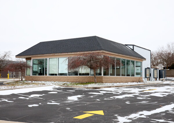
3 Peaks Enterprise LLC aims to turn the building at 120 Terrace Ave., Coldwater, into a restaurant specializing in pizzas and subs. Mercer County Commissioners green-lighted a $211,437 revolving loan to 3 Peaks Enterprise LLC for the purchase of the property, a former McDonald's restaurant.

Related online story:
  CELINA - Mercer County commissioners last week authorized revolving loans totaling over $750,000 to a trio of entities starting or expanding businesses, including a new pizza/sub joint in Coldwater and a commercial truck wash at the intersection of U.S. Route 127 and State Route 219. [More]
Additional pictures on this date