Special Weather Statement issued April 19 at 9:54AM EDT by NWS Wilmington OH (details ...)
At 954 AM EDT, a strong thunderstorm was located near Newport, moving east at 55 mph.
HAZARD...Wind gusts up to 40 mph and pea size hail.
SOURCE...Radar indicated.
IMPACT...Gusty winds could knock down tree limbs and blow around unsecured objects. Hail may cause minor damage to vegetation.
Locations impacted include... Montra, Newbern, New Jerusalem, Lockington, Ridgeway, Woodstock, Botkins, Mount Victory, Millerstown, Kiser Lake State Park, Hardin, Pemberton, Piqua, West Mansfield, East Liberty, St. Paris, Logansville, Belle Center, North Lewisburg, and Lakeview.
This includes I-75 in Ohio between mile markers 77 and 106.
If outdoors, consider seeking shelter inside a sturdy building.
To report hazardous weather conditions, go to our website at weather.gov/iln and submit your report via social media, when you can do so safely.
Today 66° Today 66° 48° 48° chance Tomorrow 64° Tomorrow 64° slight chance 58° 58° chance
Tuesday, September 25th, 2007
Inky business
Photo by Mark Pummell/The Daily Standard

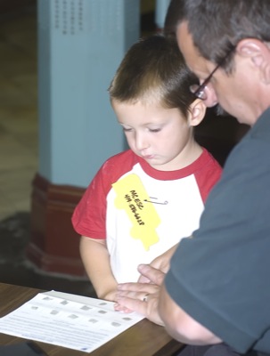
Mercer County Educational Service Center preschooler Mike Rammez gets fingerprinted by Celina Police Chief Dave Slusser during the school's tour of city hall on Monday. The child fingerprinting program, a joint local and state funded project, provides a finger print card to parents for emergency identification purposes. Slusser advises parents to update the fingerprint cards of preschoolers when a child is older to improve the quality of the print, when fingers are a little larger.

Additional pictures on this date