Flood Watch issued April 2 at 9:21PM EDT until April 6 at 8:00AM EDT by NWS Wilmington OH (details ...)
* WHAT...Flooding caused by excessive rainfall continues to be possible.
* WHERE...The following counties, in Indiana, Dearborn, Fayette, Franklin, Ohio, Ripley, Switzerland, Union and Wayne, the following counties, in Kentucky, Boone, Bracken, Campbell, Carroll, Gallatin, Grant, Kenton, Lewis, Mason, Owen, Pendleton and Robertson, and the following counties, in Ohio, Adams, Auglaize, Brown, Butler, Champaign, Clark, Clermont, Clinton, Darke, Delaware, Fairfield, Fayette, Franklin, Greene, Hamilton, Hardin, Highland, Hocking, Licking, Logan, Madison, Mercer, Miami, Montgomery, Pickaway, Pike, Preble, Ross, Scioto, Shelby, Union and Warren.
* WHEN...Through Sunday morning.
* IMPACTS...Soils remain moist and excessive runoff may result in flooding of rivers, creeks, streams, and other low-lying and flood-prone locations.
* ADDITIONAL DETAILS... - Multiple rounds of rain will occur into the weekend with the heaviest rain expect Thursday night into Friday morning and then again Saturday into Saturday night.
57° 57° chance Thu 68° Thu 68° chance 49° 49° Fri 57° Fri 57° likely
Friday, June 6th, 2008
Cooling off
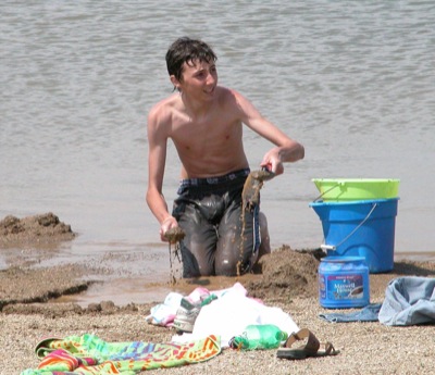
Photo by Shelley Grieshop/The Daily Standard

Nick Goedde, 13, of Celina, fills a bucket with sand during a hot afternoon at Eastview Pond in Celina on Thursday. Temperatures soared to 87 degrees during the day, making it the warmest day of the year so far.

Additional pictures on this date