Severe Thunderstorm Warning issued April 19 at 6:42AM EDT until April 19 at 7:00AM EDT by NWS Wilmington OH (details ...)
At 642 AM EDT, a severe thunderstorm was located near Celina, moving northeast at 70 mph.
HAZARD...60 mph wind gusts and penny size hail.
SOURCE...Radar indicated.
IMPACT...Expect damage to trees and power lines.
Locations impacted include... New Weston, Wabash, Tama, Chickasaw, New Bremen, Fort Recovery, Rose Hill, Maria Stein, New Knoxville, Neptune, Moulton, Coldwater, St. Marys, Chattanooga, Kossuth, Celina, North Dayton, Mendon, Burkettsville, and Montezuma.
Severe Thunderstorm Warning issued April 19 at 6:31AM EDT until April 19 at 7:00AM EDT by NWS Wilmington OH (details ...)
SVRILN
The National Weather Service in Wilmington has issued a
* Severe Thunderstorm Warning for... Shelby County in west central Ohio... Darke County in west central Ohio... Southwestern Auglaize County in west central Ohio... Southeastern Mercer County in west central Ohio... Miami County in west central Ohio...
* Until 700 AM EDT.
* At 631 AM EDT, a severe thunderstorm was located over Union City, moving northeast at 75 mph.
HAZARD...60 mph wind gusts and penny size hail.
SOURCE...Radar indicated.
IMPACT...Expect damage to trees and power lines.
* Locations impacted include... New Weston, Casstown, Union Corners, Newbern, Bradford, Potsdam, Lockington, New Bremen, Darke County Airport, Covington, State Route 47 at US Route 127, Eldora Speedway, Fort Loramie, Osgood, Hardin, Piqua, Bloomer, Greenville, Lake Loramie State Park, and Arcanum.
This includes I-75 in Ohio between mile markers 72 and 96.
Today 66° Today 66° likely 48° 48° chance Tomorrow 64° Tomorrow 64° slight chance 58° 58° chance
Saturday, July 19th, 2008
Two people hurt
Photo by Margie Wuebker/The Daily Standard

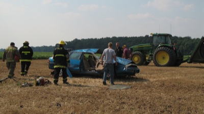
Rockford firefighters and other first responders check out a car involved in a Friday afternoon accident that resulted in injuries to two unidentified adults. The car apparently traveled off the road shortly before 4:30 p.m. and the driver overcorrected causing it to roll into a nearby field where a farmer had finished baling. The heavily damaged vehicle came to rest on its wheels with one of the occupants trapped for a short time. Ambulances transported the injured to Joint Township District Memorial Hospital in St. Marys. The report was not complete at presstime Friday night.

Additional pictures on this date