Thursday, March 17th, 2011
Funding in question
Officials visit local water quality monitoring stations
By Nancy Allen

Photo by Nancy Allen/The Daily Standard
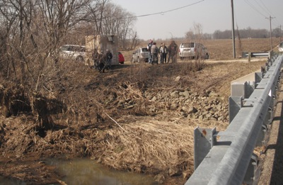
Local, Indiana and federal officials check out a water quality monitoring station on Big Chickasaw Creek Wednesday. They also visited one on Watkins Road in the Wabash River Watershed. The stations automatically collect water samples to determine nutrient levels and flow amounts.
Local, Indiana and federal officials viewed water quality monitoring stations in the Wabash River and Grand Lake watersheds on Wednesday.
Officials said funding for the stations is in question.
The station in the Wabash River Watershed is on the edge of a field located on Watkins Road, east of state Route 49. It was installed in winter and is not yet fully operational. The one in the lake watershed was installed in Big Chickasaw Creek in 2008.
A third monitoring station is being installed in Coldwater Creek but won't be completed until federal money is released. The funding is tied up in the government's continuing resolution until Congress can agree on a budget, Grand Lake-Wabash Watershed Coordinator Laura Walker said.
"We probably would have had it up and running in January or February to record the big spring flow we had, but the feds wouldn't sign off on the paperwork to let us put it in," she said.
Funding to continue operating the Big Chickasaw Creek station will run out at the end of this year, unless more money is allocated in the next Farm Bill, Walker said.
The monitoring stations automatically pull water samples and test them for levels of nutrient and flow amounts. The units can help determine if conservation practices such as filter strips, no-till and cover crops being implemented on surrounding farmland are helping improve water quality, Walker said.
"If we can get more field stations upstream and more data, the more we'll be able to see if our BMPs (best management practices) are working," she said.
The Indiana officials are part of a task force trying to decrease hypoxia in the Gulf of Mexico. High nutrient loading of phosphorous and nitrogen from midwestern states are causing hypoxic dead zones in the Gulf, threatening multi-million dollar fisheries and the ecosystem. Overflow water from Grand Lake goes to the Wabash River and eventually the Gulf.
The Indiana officials would like to have similar monitoring stations on the Wabash River in Indiana. Currently, their data is gathered by hand.
Jack Kramer with Heidelberg University, which analyzes the Big Chickasaw Creek data, said it is important to have many years of data in order to see trends, do scientific modeling and determine if conservation efforts are working.
"You need longer, continual data over many years," he said.


