Special Weather Statement issued April 4 at 1:42PM EDT by NWS Wilmington OH (details ...)
At 142 PM EDT, strong thunderstorms were located along a line extending from near Portland to Winchester, moving northeast at 35 mph. HAZARD...Wind gusts up to 50 mph. SOURCE...Radar indicated. IMPACT...Gusty winds could knock down tree limbs and blow around unsecured objects. Locations impacted include... Celina, Coldwater, St. Henry, Fort Recovery, Rockford, Wabash, Mendon, Chickasaw, Burkettsville, Montezuma, New Weston, Chattanooga, Tama, North Dayton, Rose Hill, Cosmos, Neptune, and Carthagena. If outdoors, consider seeking shelter inside a sturdy building. To report hazardous weather conditions, go to our website at weather.gov/iln and submit your report via social media, when you can do so safely.
Tuesday, May 1st, 2012
Photo by Mark Pummell/The Daily Standard
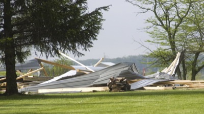
Strong winds destroyed a barn being constructed along Mud Pike near Celina on Monday evening. The storm also took down trees and utility poles in Celina and St. Marys, causing power outages in both cities.