Flood Watch issued September 17 at 2:22AM EDT until September 17 at 2:00PM EDT by NWS Wilmington OH (details ...)
* WHAT...Flash flooding caused by excessive rainfall continues to be possible.
* WHERE...Portions of central and west central Ohio, including the following counties, in central Ohio, Delaware, Franklin, Licking, Madison and Union. In west central Ohio, Auglaize, Champaign, Clark, Darke, Hardin, Logan, Mercer, Miami and Shelby.
* WHEN...Until 2 PM EDT this afternoon.
* IMPACTS...Excessive runoff may result in flooding of rivers, creeks, streams, and other low-lying and flood-prone locations.
* ADDITIONAL DETAILS... - Multiple rounds of showers and thunderstorms will move across parts of the area this morning, possibly extending into early afternoon. This may result in bands of heavier rainfall that could lead to flash flooding.
68° 68° chance Thu 84° Thu 84° likely 65° 65° slight chance Fri 77° Fri 77°
Saturday, January 19th, 2013
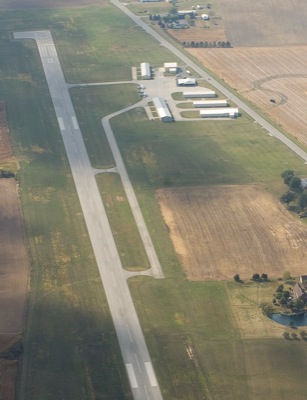
Photo by Mark Pummell/The Daily Standard

An aerial photo of Lakefield Airport taken in 2010 shows the facility along state Route 219. A study is under way by state and federal officials to determine the value of Ohio's 97 publicly-owned airports such as the local one in Montezuma.

Related online story:

MONTEZUMA - A study on how important public airports are to communities could decide the fate of the local airstrip.
Information gathered in the ne [More]
Additional pictures on this date