Monday, November 17th, 2014
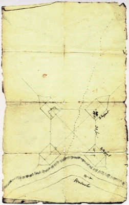
Original 1793 fort plan found
Large crowd fills church to learn about new artifact
By William Kincaid

Photo by William Kincaid/The Daily Standard
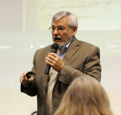
Historian David Heckaman on Sunday afternoon speaks to a large crowd in Fort Recovery about the recent discovery of the original plans for the historic fort. The plan likely was created by Gen. Anthony Wayne.
FORT RECOVERY - An original construction plan for Fort Recovery has been found to the surprise and elation of historians and museum officials.
A large crowd of both locals and out-of-town history enthusiasts packed the Fort Recovery Nazarene Church Family Center on Sunday afternoon for a presentation of the recently discovered plat of Fort Recovery, likely drawn by Gen. Anthony Wayne. The plat was sent in a Dec. 22, 1793, letter to Henry Burbeck, who commanded the artillery of Wayne's Legion of the United States in the Northwest Territory.
The discovery was made when researchers at the University of Michigan's Clements Library began sifting through nearly six cubic feet of Burbeck's papers that the university recently had acquired.
Before the find, the original fort documents were believed to have been destroyed.
"When people would ask about the fort of Fort Recovery, what we would have to say was, 'Well, we don't know exactly what the fort looked like, how it was designed and so forth," Nancy Knapke, director of the Fort Recovery State Museum, said. "But the reason we can't tell you is because the actual map of Fort Recovery was burned in the War of 1812 when the British burned Washington, D.C. So our fort's plans actually contributed to that great flame there back in 1812. Well, that was quite the story I guess because now we find out that indeed there are original plans that exist."
The plat is drawn on rag paper, according to history expert David Heckaman.
"You see a river. You see an embankment. You see the square fort, and again it's drawn out so that it is square. You've got angles there. You've got triangles and then you've got these projections from the corners," said David Simmons, senior editor of Ohio History Connection's Timeline Magazine.
Previously, some experts thought the fort, built in December 1793 at the site of Gen. Arthur St. Clair's disastrous defeat by Native Americans, was rectangular, Heckaman said.
"This shows us the shape is a square. But more importantly, it shows the dimensions along the walls and blockhouses, it shows those - 32 feet on the wall, 22 feet on the blockhouse ... and that's very small," Heckaman said.
As many as 300 soldiers would have been able to fit within the walls, Heckaman said.
After the United States suffered its worst defeat ever at the Battle of Wabash on Nov. 4, 1791, Wayne was selected by President George Washington in 1792 to create an army to fight the Native Americans.
As early as August 1792, Wayne was obsessed with building a fort at the site of Sinclair's defeat, Heckaman said. In a letter to the secretary of war, Wayne wrote that the recent U.S. defeats could not be permitted to pass with impunity unless the nascent country were willing to sacrifice its national character and justice, Heckaman said. Wayne, in a Dec. 22, 1793, letter enclosed with the recently rediscovered plat, ordered Burbeck to march troops to the site and build a small fort with four blockhouses on the south side of the Wabash River, which has since been rerouted.
Construction began on Christmas Eve.
"Not too many people liked Wayne, but Wayne was really prepared. He thought of everything, and he told them exactly what to do during the day and have the wall up high enough to protect them," Heckaman said.
Brubeck spoke of the massive number of bones from as many as 1,200 soldiers who perished under St. Clair that were buried in the middle of the Fort Recovery.
Heckaman and other speakers on Sunday hailed the finding of the plat as a significant event but said more maps may exist. Among the Brubeck papers are previously unknown renderings of Fort Mackinac, Fort Detroit and Fort Defiance, according to Knapke. Richard Smith, a Fort Recovery native and museum patron, notified Knapke of the findings after reading about them in the September/October issue of Michigan History Magazine.
"The Clements Library just bought these, maybe last fall," Heckaman said. "They bought them from a collector and they cost a good amount of money plus they're putting some money into conserving these so that they will be there 50 years, 100 years for other people to look at them."
Researcher David Cox, also present on Sunday afternoon, marveled at the finding.
"As far as significant - we keep using that term 'significant' - but this little drawing is awesome. It would have been on my bucket list of things to see before I died."
Several other researchers, now dead, spent much time searching for such a document, Cox said.
"I just think it's sort of sad that they never got to see what we're looking at right now," he said.
Ball State archaeologist Chris Thompson, a Fort Recovery native, spoke of her work with a team of archeologists who in 2011 likely discovered the location of the east-west palisade wall of the original fort built in 1793.
The team excavated a 17-foot trench at the corner of Boundary and Fort Site streets believed to be the site of the former fort.
Excavation revealed the clay surface of the trench as well as several post holes that likely had held the timbers constituting the fort wall.
Also, several period artifacts - lead-glazed flowerpots, ceramics, shells, a fire-striker, a pair of scissors, lantern hardware and the middle bracket of a 1766 Charleville Musket - were found in or near the post holes.

Submitted Photo
Researchers at the University of Michigan's Clements Library found an original plat for Fort Recovery while sifting through nearly six cubic feet of Henry Burbeck's papers, which the university recently acquired.

