Frost Advisory issued April 5 at 1:22PM EDT until April 6 at 10:00AM EDT by NWS Wilmington OH (details ...)
* WHAT...For the Frost Advisory, temperatures as low as 34 will result in frost formation. For the Freeze Watch, sub-freezing temperatures as low as 27 possible. * WHERE...Portions of east central and southeast Indiana and central, south central, southwest, and west central Ohio. * WHEN...For the Frost Advisory, from 1 AM to 10 AM EDT Monday. For the Freeze Watch, from late Monday night through Tuesday morning. * IMPACTS...Frost and freeze conditions could kill crops, other sensitive vegetation and possibly damage unprotected outdoor plumbing. Frost could harm sensitive outdoor vegetation. Sensitive outdoor plants may be killed if left uncovered.
Freeze Watch issued April 5 at 1:22PM EDT until April 7 at 10:00AM EDT by NWS Wilmington OH (details ...)
* WHAT...For the Frost Advisory, temperatures as low as 34 will result in frost formation. For the Freeze Watch, sub-freezing temperatures as low as 27 possible. * WHERE...Portions of east central and southeast Indiana and central, south central, southwest, and west central Ohio. * WHEN...For the Frost Advisory, from 1 AM to 10 AM EDT Monday. For the Freeze Watch, from late Monday night through Tuesday morning. * IMPACTS...Frost and freeze conditions could kill crops, other sensitive vegetation and possibly damage unprotected outdoor plumbing. Frost could harm sensitive outdoor vegetation. Sensitive outdoor plants may be killed if left uncovered.
Friday, January 2nd, 2015
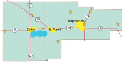
Photo by Daily Standard Staff
The stars on the map show the locations of fatal traffic accidents in Mercer and Auglaize counties in 2014.
Local traffic deaths declined in 2014 from the previous year and authorities hope to make it a trend.
Area law enforcement officers said they will continue to monitor "hot spots" where accidents more frequently occur, as well as target impaired drivers and those not wearing seat belts. [More]