Severe Thunderstorm Watch issued March 31 at 6:02PM EDT until April 1 at 12:00AM EDT by NWS Wilmington OH (details ...)
THE NATIONAL WEATHER SERVICE HAS ISSUED SEVERE THUNDERSTORM WATCH 82 IN EFFECT UNTIL MIDNIGHT EDT TONIGHT FOR THE FOLLOWING AREAS
IN OHIO THIS WATCH INCLUDES 3 COUNTIES
IN WEST CENTRAL OHIO
AUGLAIZE HARDIN MERCER
THIS INCLUDES THE CITIES OF ADA, CELINA, COLDWATER, KENTON, MINSTER, NEW BREMEN, ST. MARYS, AND WAPAKONETA.
Today 78° Today 78° chance 52° 52° chance Tomorrow 60° Tomorrow 60° 47° 47° likely
Thursday, September 3rd, 2015
Rollover crash
Photo by Mark Pummell/The Daily Standard

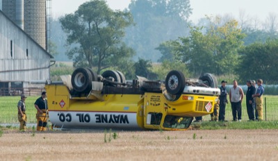
Emergency crews tend to a 1996 International tanker truck that overturned into a field off the west side of Burrville Road north of Siegrist-Jutte Road on Wednesday morning. The vehicle was southbound on Burrville Road when it reportedly traveled off the roadway into a ditch and overturned. The driver, David Link, 1484 Burrville Road, Fort Recovery, reported no injuries. No citations were listed on the report.

Additional pictures on this date