Flood Watch issued August 14 at 2:57PM EDT until August 16 at 8:00AM EDT by NWS Wilmington OH (details ...)
* WHAT...Flash flooding caused by excessive rainfall is possible.
* WHERE...Portions of Indiana, including the following counties, Fayette, Franklin, Union and Wayne and Ohio, including the following counties, Auglaize, Butler, Champaign, Clark, Clinton, Darke, Delaware, Fairfield, Fayette, Franklin, Greene, Hardin, Hocking, Licking, Logan, Madison, Mercer, Miami, Montgomery, Pickaway, Preble, Ross, Shelby, Union and Warren.
* WHEN...From Saturday afternoon through Sunday morning.
* IMPACTS...Excessive runoff may result in flooding of rivers, creeks, streams, and other low-lying and flood-prone locations.
* ADDITIONAL DETAILS... - Another round of showers and thunderstorms is expected to move through the region Saturday into Saturday night. Given the saturated ground, additional heavy rainfall may result in flash flooding.
Today 82° Today 82° likely chance 70° 70° chance Tomorrow 84° Tomorrow 84° chance 74° 74° chance likely
Saturday, July 30th, 2016
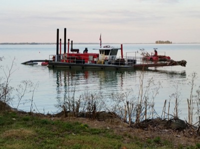
Dredging in progress
Photo by Nancy Allen/The Daily Standard

The dredge Brutus floats in the water along Grand Lake's west bank this week. The state has begun a project to remove 340,000 cubic yards of sediment from a 60-acre area east of the Celina Rotary Dog Park and extending into the mouth of Coldwater Creek. The dredged sediment will be used to construct wetlands in the Coldwater Creek treatment train, said Grand Lake St. Marys State Park Manager Dave Faler. The project is expected to take several months. Boaters are advised to avoid the submerged dredge line, which is marked by orange floating balls, Faler said.


Additional pictures on this date