Extreme Heat Warning issued July 3 at 11:21AM EDT until July 3 at 8:00PM EDT by NWS Wilmington OH (details ...)
* WHAT...For the Extreme Heat Warning, dangerously hot conditions with heat index values around 105 are expected. For the Heat Advisory, heat index values around 100 are expected. * WHERE...Portions of east central and southeast Indiana, northeast and northern Kentucky, and central, south central, southwest, and west central Ohio. * WHEN...For the Extreme Heat Warning, until 8 PM EDT this evening. For the Heat Advisory, from 8 PM this evening to 8 PM EDT Saturday. * IMPACTS...Heat related illnesses increase significantly during extreme heat and high humidity events, particularly for those working or participating in outdoor activities. Hot temperatures and high humidity may cause heat illnesses. * ADDITIONAL DETAILS...Remember, multiple days with excessive heat can have compounding effects.
Heat Advisory issued July 3 at 11:21AM EDT until July 4 at 8:00PM EDT by NWS Wilmington OH (details ...)
* WHAT...For the Extreme Heat Warning, dangerously hot conditions with heat index values around 105 are expected. For the Heat Advisory, heat index values around 100 are expected. * WHERE...Portions of east central and southeast Indiana, northeast and northern Kentucky, and central, south central, southwest, and west central Ohio. * WHEN...For the Extreme Heat Warning, until 8 PM EDT this evening. For the Heat Advisory, from 8 PM this evening to 8 PM EDT Saturday. * IMPACTS...Heat related illnesses increase significantly during extreme heat and high humidity events, particularly for those working or participating in outdoor activities. Hot temperatures and high humidity may cause heat illnesses. * ADDITIONAL DETAILS...Remember, multiple days with excessive heat can have compounding effects.
Special Weather Statement issued July 3 at 7:22PM EDT by NWS Wilmington OH (details ...)
At 722 PM EDT, a strong thunderstorm was located near Wapakoneta, moving east at 45 mph. HAZARD...Wind gusts up to 40 mph. SOURCE...Radar indicated. IMPACT...Gusty winds could knock down tree limbs and blow around unsecured objects. Locations impacted include... Wapakoneta, St. Marys, Fort Shawnee, Cridersville, New Knoxville, Waynesfield, Moulton, Buckland, Uniopolis, Fryburg, Kossuth, St. Johns, and New Hampshire. This includes I-75 in Ohio between mile markers 107 and 118. If outdoors, consider seeking shelter inside a sturdy building. To report hazardous weather conditions, go to our website at weather.gov/iln and submit your report via social media, when you can do so safely.
Ralph A. Heil, 99, passed away peacefully surrounded by his family Wednesday, August 17, 2016 at Parkview Regional Medical Center, Fort Wayne, Indiana. [More]
CELINA - Early voting in Mercer County for the special Democratic primary election began Tuesday, and so far only one person, a military voter, has requested an absentee ballot.
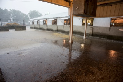
WAPAKONETA - Officials are looking at possible improvements to the fairgrounds before the 2017 Auglaize County Fair.
Fair Secretary Fred Piehl on Thursday asked county commissioners if they would be able to split the $63,000 cost of replacing two roofs and paving a gravel parking area.