Flood Advisory issued July 11 at 3:58PM EDT until July 11 at 7:00PM EDT by NWS Wilmington OH (details ...)
* WHAT...Flooding caused by excessive rainfall is expected.
* WHERE...The following counties, in west central Ohio, Auglaize, Darke, Mercer and Shelby.
* WHEN...Until 700 PM EDT.
* IMPACTS...Minor flooding in low-lying and poor drainage areas.
* ADDITIONAL DETAILS... - At 356 PM EDT, radar indicated heavy rain due to thunderstorms. Minor flooding is ongoing or expected to begin shortly in the advisory area. Between 1 and 2 inches of rain have fallen. Additional rainfall amounts of 0.5 to 1 inch are possible. - Some locations that may experience flooding include... Fort Loramie, New Bremen, Minster, Newport, New Knoxville, Russia, Osgood, Willowdell, Chickasaw, Kettlersville, Yorkshire, Lake Loramie State Park, Egypt, Maria Stein, Mccartyville and Houston.
Today 81° Today 81° chance 67° 67° chance Tomorrow 83° Tomorrow 83° 66° 66°
Thursday, August 25th, 2016
Submitted Photo

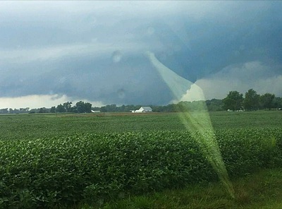
A tornado touches down across the state line in Indiana at about 5:50 p.m. Wednesday. Chattanooga and Rockford fire personnel were dispatched as weather spotters for the northwest portion of Mercer County. One of those spotters took this photo through a vehicle window.

Related online story:


Mercer County dodged a bullet Wednesday as a storm front that spawned tornadoes that flattened parts of Kokomo, Ind., weakened locally before picking up steam again in Van Wert and Defiance counties. [More]
Additional pictures on this date