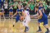
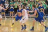
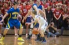
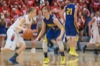
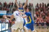
Marion Local vs Tri-Village boys basketball
120 of 129 pictures
Friday, March 14th, 2014
Photo by Mark Pummell/The Daily Standard
Tornado Warning issued June 16 at 8:08PM EDT until June 16 at 8:45PM EDT by NWS Wilmington OH (details ...)
TORILN
The National Weather Service in Wilmington has issued a
* Tornado Warning for... Northwestern Auglaize County in west central Ohio... Northeastern Mercer County in west central Ohio...
* Until 845 PM EDT.
* At 808 PM EDT, a severe thunderstorm capable of producing a tornado was located near Celina, moving east at 30 mph.
HAZARD...Tornado.
SOURCE...Weather spotters reported funnel cloud.
IMPACT...Flying debris will be dangerous to those caught without shelter. Mobile homes will be damaged or destroyed. Damage to roofs, windows, and vehicles will occur. Tree damage is likely.
* Locations impacted include... Fort Shawnee, Cridersville, Mendon, Buckland, Neptune, Kossuth, and State Route 116 at State Route 197.
This includes I-75 in Ohio between mile markers 117 and 118.
56° 56° chance Wed 77° Wed 77° likely 66° 66° Thu 75° Thu 75° slight chance
thum pict
thum pict
thum pict
thum pict
thum pict
thum pict
thum pict
thum pict
thum pict
thum pict
thum pict
thum pict
thum pict
thum pict
thum pict
thum pict
thum pict
thum pict
thum pict
thum pict
thum pict
thum pict
thum pict
thum pict
thum pict
thum pict
thum pict
thum pict
thum pict
thum pict
thum pict
thum pict
thum pict
thum pict
thum pict
thum pict
thum pict
thum pict
thum pict
thum pict
thum pict
thum pict
thum pict
thum pict
thum pict
thum pict
thum pict
thum pict
thum pict
thum pict
thum pict
thum pict
thum pict
thum pict
thum pict
thum pict
thum pict
thum pict
thum pict
thum pict
thum pict
thum pict
thum pict
thum pict
thum pict
thum pict
thum pict
thum pict
thum pict
thum pict
thum pict
thum pict
thum pict
thum pict
thum pict
thum pict
thum pict
thum pict
thum pict
thum pict
thum pict
thum pict
thum pict
thum pict
thum pict
thum pict
thum pict
thum pict
thum pict
thum pict
thum pict
thum pict
thum pict
thum pict
thum pict
thum pict
thum pict
thum pict
thum pict
thum pict
thum pict
thum pict
thum pict
thum pict
thum pict
thum pict
thum pict
thum pict
thum pict
thum pict
thum pict
thum pict
thum pict
thum pict
thum pict
thum pict
thum pict
thum pict
thum pict
thum pict
thum pict
thum pict
thum pict
thum pict
thum pict
thum pict
thum pict
thum pict
thum pict