Heat Advisory issued June 23 at 3:02AM EDT until June 25 at 8:00PM EDT by NWS Wilmington OH (details ...)
* WHAT...Heat index values of 100 to 105.
* WHERE...Portions of east central and southeast Indiana, northeast and northern Kentucky, and central, south central, southwest, and west central Ohio.
* WHEN...Until 8 PM EDT Wednesday.
* IMPACTS...Hot temperatures and high humidity may cause heat illnesses.
* ADDITIONAL DETAILS...Consecutive days of excessive heat and humidity can be especially hazardous as warm overnight temperatures will provide little relief. The heat may continue into Thursday.
Today 95° Today 95° 74° 74° Tomorrow 94° Tomorrow 94° slight chance 74° 74° slight chance
Tuesday, June 16th, 2015
Area flooding reported
Photo by Mark Pummell/The Daily Standard

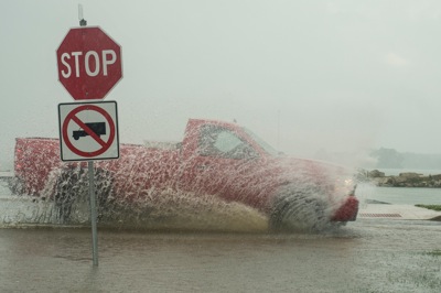
A truck drives through the flooded intersection of Ash Street and Lakeshore Drive Monday evening during the heavy rainfall. According to emergency officials, rainfall totals varied widely, from less than an inch in southern New Bremen to 5.2 inches in St. Marys. In the last three days, Rockford has had six inches of rain. Flooding closed several roads in Auglaize and Mercer counties. Motorists are advised to avoid driving through standing water.

Additional pictures on this date