Special Weather Statement issued May 1 at 8:06PM EDT by NWS Wilmington OH (details ...)
At 806 PM EDT, a strong thunderstorm was located over Monroe, moving northeast at 35 mph.
HAZARD...Wind gusts up to 45 mph and pea size hail.
SOURCE...Radar indicated.
IMPACT...Gusty winds could knock down tree limbs and blow around unsecured objects. Hail may cause minor damage to vegetation.
This storm will remain over mainly rural areas of northwestern Mercer County.
If outdoors, consider seeking shelter inside a sturdy building.
To report hazardous weather conditions, go to our website at weather.gov/iln and submit your report via social media, when you can do so safely.
57° 57° likely slight chance Fri 72° Fri 72° chance 53° 53° likely Sat 59° Sat 59° likely
Monday, March 6th, 2017
Photo by Ed Gebert/The Daily Standard

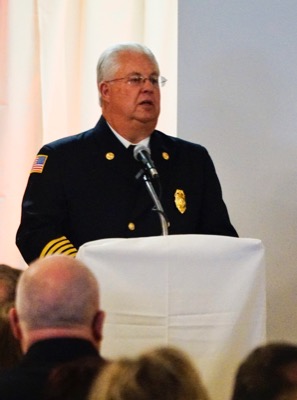
Retiring chief Dale Dues is honored Sunday at the Minster Knights of Columbus Hall for his 40 years of service with the Minster-Jackson Township Fire Department.

Related online story:
MINSTER - Well-wishers from the village, Jackson Township and all over the state turned out Sunday to honor retiring fire chief Dale Dues.
A commem [More]
Additional pictures on this date