Flood Watch issued April 4 at 4:27AM EDT until April 6 at 8:00AM EDT by NWS Wilmington OH (details ...)
* WHAT...Flooding caused by excessive rainfall continues to be possible.
* WHERE...The following counties, in Indiana, Dearborn, Fayette, Franklin, Ohio, Ripley, Switzerland, Union and Wayne, the following counties, in Kentucky, Boone, Bracken, Campbell, Carroll, Gallatin, Grant, Kenton, Lewis, Mason, Owen, Pendleton and Robertson, and the following counties, in Ohio, Adams, Auglaize, Brown, Butler, Champaign, Clark, Clermont, Clinton, Darke, Delaware, Fairfield, Fayette, Franklin, Greene, Hamilton, Hardin, Highland, Hocking, Licking, Logan, Madison, Mercer, Miami, Montgomery, Pickaway, Pike, Preble, Ross, Scioto, Shelby, Union and Warren.
* WHEN...Through Sunday morning.
* IMPACTS...Soils remain moist and excessive runoff may result in flooding of rivers, creeks, streams, and other low-lying and flood-prone locations.
* ADDITIONAL DETAILS... - Multiple rounds of showers and thunderstorms will occur into the weekend with the heaviest rain expected Saturday into Saturday night.
46° 46° Fri 58° Fri 58° likely 51° 51° Sat 64° Sat 64°
Tuesday, May 1st, 2018
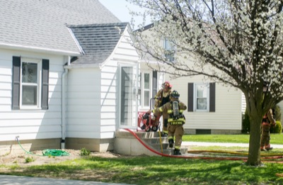
St. Henry fire
Photo by Mark Pummell/The Daily Standard

Firefighters use a fan to vent smoke from a home at 361 E. Kremer-Hoying Road in St. Henry at 10:59 a.m. on Monday. St. Henry Fire Chief Matt Lefeld said flammable materials in a trash can spontaneously combusted inside the home, which is under construction, causing about $10,000 in smoke damage. The fire was reported by a passerby and about 30 firefighters from St. Henry, Burkettsville and Coldwater departments responded with a total of seven trucks. No one was injured and firefighters returned to the station at about 1 p.m.

Additional pictures on this date