Severe Thunderstorm Warning issued June 18 at 6:13PM EDT until June 18 at 7:00PM EDT by NWS Wilmington OH (details ...)
SVRILN
The National Weather Service in Wilmington has issued a
* Severe Thunderstorm Warning for... Shelby County in west central Ohio... Darke County in west central Ohio... Auglaize County in west central Ohio... Eastern Mercer County in west central Ohio... Miami County in west central Ohio...
* Until 700 PM EDT.
* At 613 PM EDT, severe thunderstorms were located along a line extending from near Rockford to New Madison, moving east at 55 mph.
HAZARD...60 mph wind gusts.
SOURCE...Public.
IMPACT...Expect damage to trees and power lines.
* Locations impacted include... Troy, Sidney, Piqua, Greenville, Celina, Wapakoneta, St. Marys, West Milton, Coldwater, Fort Shawnee, New Bremen, Minster, Versailles, Covington, St. Henry, Arcanum, Newport, Cridersville, Bradford, and Anna.
This includes I-75 in Ohio between mile markers 71 and 118.
Severe Thunderstorm Warning issued June 18 at 5:46PM EDT until June 18 at 6:30PM EDT by NWS Wilmington OH (details ...)
SVRILN
The National Weather Service in Wilmington has issued a
* Severe Thunderstorm Warning for... Darke County in west central Ohio... Mercer County in west central Ohio...
* Until 630 PM EDT.
* At 545 PM EDT, severe thunderstorms were located along a line extending from 6 miles southeast of Bluffton to 10 miles north of Hagerstown, moving northeast at 60 mph.
HAZARD...70 mph wind gusts and penny size hail.
SOURCE...Emergency management.
IMPACT...Expect considerable tree damage. Damage is likely to mobile homes, roofs, and outbuildings.
* Locations impacted include... Greenville, Celina, Coldwater, Versailles, St. Henry, Bradford, Union City, Fort Recovery, Ansonia, Rockford, Webster, Wabash, Wayne Lakes, Mendon, Gettysburg, Osgood, Chickasaw, Burkettsville, North Star, and Rossburg.
Severe Thunderstorm Watch issued June 18 at 4:51PM EDT until June 18 at 10:00PM EDT by NWS Wilmington OH (details ...)
THE NATIONAL WEATHER SERVICE HAS ISSUED SEVERE THUNDERSTORM WATCH 437 IN EFFECT UNTIL 10 PM EDT THIS EVENING FOR THE FOLLOWING AREAS
IN INDIANA THIS WATCH INCLUDES 8 COUNTIES
IN EAST CENTRAL INDIANA
FAYETTE UNION WAYNE
IN SOUTHEAST INDIANA
DEARBORN FRANKLIN OHIO RIPLEY SWITZERLAND
IN KENTUCKY THIS WATCH INCLUDES 12 COUNTIES
IN NORTHEAST KENTUCKY
LEWIS
IN NORTHERN KENTUCKY
BOONE BRACKEN CAMPBELL CARROLL GALLATIN GRANT KENTON MASON OWEN PENDLETON ROBERTSON
IN OHIO THIS WATCH INCLUDES 32 COUNTIES
IN CENTRAL OHIO
DELAWARE FAIRFIELD FAYETTE FRANKLIN HOCKING LICKING MADISON PICKAWAY UNION
IN SOUTH CENTRAL OHIO
ADAMS HIGHLAND PIKE ROSS SCIOTO
IN SOUTHWEST OHIO
BROWN BUTLER CLERMONT CLINTON HAMILTON WARREN
IN WEST CENTRAL OHIO
AUGLAIZE CHAMPAIGN CLARK DARKE GREENE HARDIN LOGAN MERCER MIAMI MONTGOMERY PREBLE SHELBY
THIS INCLUDES THE CITIES OF ABERDEEN, ADA, ALEXANDRIA, AUGUSTA, AURORA, BATESVILLE, BEAVERCREEK, BELLEFONTAINE, BELLEVUE, BLANCHESTER, BRIGHT, BROOKSVILLE, BROOKVILLE, BURLINGTON, BUTLER, CAMDEN, CAMP DIX, CARROLLTON, CELINA, CHILLICOTHE, CIRCLEVILLE, COLDWATER, CONNERSVILLE, COVINGTON, CRITTENDEN, DAY HEIGHTS, DAYTON, DELAWARE, DILLSBORO, DOWNTOWN CINCINNATI, DOWNTOWN COLUMBUS, DOWNTOWN DAYTON, DRY RIDGE, EATON, ERLANGER, FAIRBORN, FAIRFIELD, FALMOUTH, FLORENCE, FORT THOMAS, FRANKLIN, GEORGETOWN, GREENDALE, GREENFIELD, GREENVILLE, HAMILTON, HEAD OF GRASSY, HIDDEN VALLEY, HIGHLAND HEIGHTS, HILLSBORO, INDEPENDENCE, KENTON, KETTERING, LANCASTER, LANDEN, LAWRENCEBURG, LEBANON, LIBERTY, LOGAN, LONDON, MANCHESTER, MARYSVILLE, MASON, MAYSVILLE, MIDDLETOWN, MILAN, MILFORD, MINSTER, MOUNT CARMEL, MOUNT OLIVET, MOUNT ORAB, MOUNT REPOSE, MULBERRY, NEW BREMEN, NEWARK, NEWPORT, OAKBROOK, OSGOOD, OWENTON, OXFORD, PEEBLES, PICKERINGTON, PIKE LAKE, PIKETON, PIQUA, PLAIN CITY, PORTSMOUTH, RICHMOND, RIPLEY, RISING SUN, SEAMAN, SIDNEY, SPRINGBORO, SPRINGFIELD, ST. MARYS, SUMMERSIDE, TIPP CITY, TOLLESBORO, TROY, URBANA, VANCEBURG, VERSAILLES, VEVAY, WAPAKONETA, WARSAW, WASHINGTON COURT HOUSE, WAVERLY, WEST COLLEGE CORNER, WEST JEFFERSON, WEST UNION, WHEELERSBURG, WILLIAMSTOWN, WILMINGTON, WINCHESTER, WITHAMSVILLE, AND XENIA.
Today 85° Today 85° chance 66° 66° likely Tomorrow 77° Tomorrow 77° chance 63° 63°
Tuesday, October 31st, 2023
Obituaries on October 31st, 2023
Stephen P. Lefeld, age 72, of Coldwater/Montezuma, died on Sunday, October 29, 2023 at Mercer County Community Hospital in Coldwater. [More]
Robert William Bollinger, also known as Bob, passed away on October 28, 2023, at the age of 66 in Dublin, Ohio. [More]
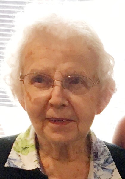
Doris Marie (Hildbold) Cheeseman, a native of Fort Recovery, Ohio, passed away on Saturday, October 28, 2023, at Swiss Village in Berne, Indiana. She was 97. [More]
Rosetta K. Mertz, 92, of Botkins, passed away at 5:00 a.m., Saturday, October 28, 2023 at Otterbein Cridersville. [More]
Deborah "Deb" J. Green, 73, of Celina, Ohio, passed away on October 28, 2023, at Miami Valley Hospital in Dayton. [More]
Stories on October 31st, 2023
CELINA - Celina Mercer County Chamber of Commerce and city officials late last week unveiled a long-awaited signage project in the downtown area.
A
Brand new venue opens
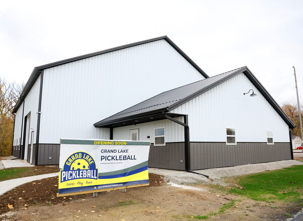
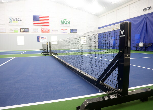
ST. MARYS - Rest assured, pickleball is not just a phase for the St. Marys Grand Lake Region. At least, that is according to Jason and Sheila Vanderhorst of St. Marys.
FORT RECOVERY - A poultry and swine farm authorized to house up to 370,000 chickens and 2,000 swine is seeking a five-year permit to operate renewal from the Ohio Department of Agriculture.
The MAC at 50
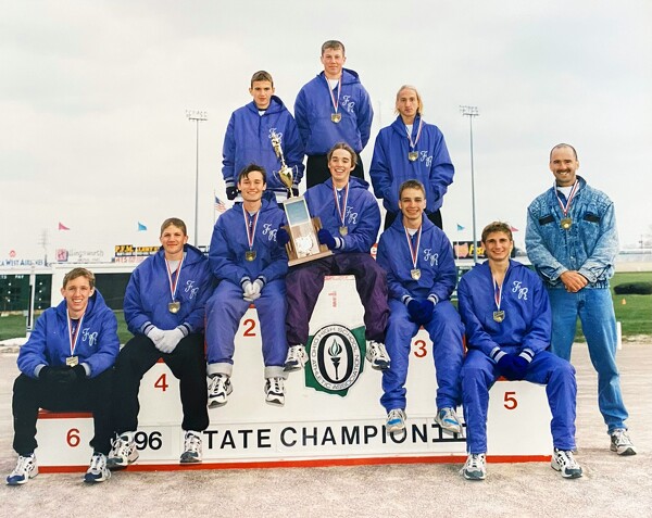
1996 Fort Recovery cross country dominated the field
The bond between teammates remains strong over the years.
For the members of Fort Recovery's 1996 Division III state boys cross country championship team, that connection remains strong despite the miles that separate them. [More]
Grand Lake Fishing Report
We are in full swing of fall, and it's starting to feel like we're going into winter with the first chance of snow in the forecast. This gets me excited, but also scared that the ice is coming.
Local pictures on October 31st, 2023