Wednesday, May 29th, 2019
EF3 tornado wind speed reached 150 mph
By William Kincaid

Photo by Ryan Snyder/The Daily Standard
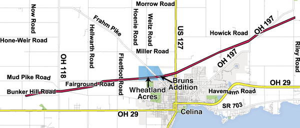
This map shows the path of destruction of Monday night's EF3 tornado. The roughly 10-mile path began along Bunker Hill Road and then traveled slightly northeast and ended near Neptune.
CELINA - The twister that tore up northwestern Celina on Monday night was at least an EF3 tornado, packing top wind speeds of 150 mph, according to the National Weather Service of Wilmington.
The survey is ongoing, but on Tuesday afternoon Van Wert County Emergency Management Agency Director Rick McCoy said it was likely a very powerful tornado.
More tornadoes could be in store for the area through June based on national weather patterns, he said.
McCoy, working on behalf of the National Weather Service of Wilmington, spoke to reporters at a news conference in Celina on Tuesday afternoon.
"What I've seen so far is the tornado was a quarter-mile wide, at least here in the city of Celina," he said. "I haven't got out in the country to see what the width is out there."
That's a very large tornado, he said.
"From what I've seen it may have been wider out in some other areas," he said. "That was just here in the city and, of course, we've got more damage out in the country."
Asked how far the tornado traveled, McCoy said he didn't know for sure but surmised perhaps as far as 5 miles.
"At least 3 miles, maybe more to the west of Celina, and it goes off to the north of Celina and just out to the north of town."
Mercer County EMA Director Mike Robbins said the tornado likely touched down in western Mercer County near Bunker Hill Road and traveled down Fairground Road.
The first obvious major visible damage was along Bunker Hill Road. The apparent trail then headed east and slightly north across State Route 118, Mud Pike, Hellwarth, Fleetfoot and Fairground roads. It then clipped the northern edge of Celina through the Wheatland Acres and Bruns Addition neighborhoods. The path is only hundreds of feet from homes on Heritage Court on the north edge of Celina. Finally it crossed Celina-Mendon Road, State Route 197, Howick and Riley roads before dissipating south of Neptune.
McCoy said the focus of his survey is Fairground Road.
"The one location that I'm really looking closely at is on Fairground Road, out here, just out to the west of town where there is one home that is completely gone," McCoy said. "I've just got a bare foundation. The house is out in the field. The house right next to it is where the one gentleman (Melvin Hanna, 81) was killed so it was very intense right there at that location."
McCoy also noted the tornado may have contained multiple vortices.
"When you have the big apparent tornado on the ground, if it's a large violent tornado, a lot of times you'll have little multiple vortices," he explained.
McCoy said to the naked eye, vortices look like little tornadoes spinning around within the big tornado.
"A lot of times we'll see winds in those multiple vortices 100 mile an hour higher than what we've seen in the big apparent tornado, and those are the ones that actually act like suction cups," he said. "Everything will explode where they hit."
Vortices can explain why one house may be destroyed in a tornado and the one next to it is not, he said.
People in the area were adequately warned of the tornado in advance, McCoy stressed.
"What was very important about Celina here is that the warnings were out ahead of time," he said. "People were using technology that we have. We have so much of it today with the alert systems and the sirens and media and the National Weather Service putting out very good information."
Those warnings certainly saved many lives in Celina, he said.
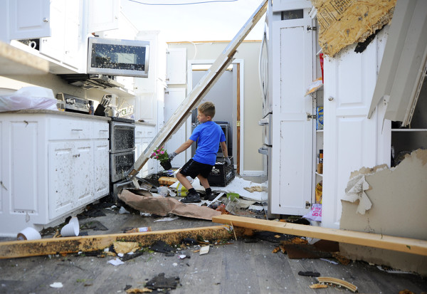
"I've talked to so many people that their homes were literally obliterated, and I've continuously asked them, 'How did you survive this?' " McCoy said.
The answers were they heard the warnings and went down into their basements, he said.
The nation as a whole is seeing a very wet, stormy pattern with many tornadoes in the southern states, which could be an ominous sign for the area, according to McCoy.
"Normally in years when we see that, we see that advance to the north," he said. "So now that we've got our warmer temperatures here, (and) we're still in that wet pattern, I expect that we're going to see a lot more tornadoes across Indiana and Ohio here through the month of June and that's just the pattern that we're going to be in."
"Again, this is an active year. It's a dangerous year," he continued. "People across our area need to be very well prepared."
Find links to all other tornado coverage on this page including stories, map, albums and video.
