Special Weather Statement issued April 19 at 9:54AM EDT by NWS Wilmington OH (details ...)
At 954 AM EDT, a strong thunderstorm was located near Newport, moving east at 55 mph. HAZARD...Wind gusts up to 40 mph and pea size hail. SOURCE...Radar indicated. IMPACT...Gusty winds could knock down tree limbs and blow around unsecured objects. Hail may cause minor damage to vegetation. Locations impacted include... Montra, Newbern, New Jerusalem, Lockington, Ridgeway, Woodstock, Botkins, Mount Victory, Millerstown, Kiser Lake State Park, Hardin, Pemberton, Piqua, West Mansfield, East Liberty, St. Paris, Logansville, Belle Center, North Lewisburg, and Lakeview. This includes I-75 in Ohio between mile markers 77 and 106. If outdoors, consider seeking shelter inside a sturdy building. To report hazardous weather conditions, go to our website at weather.gov/iln and submit your report via social media, when you can do so safely.
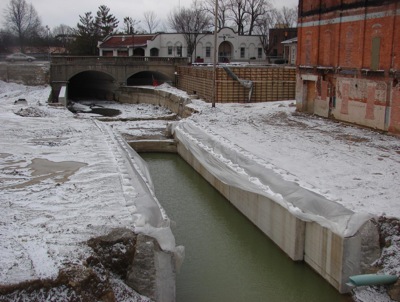
ST. MARYS - The restoration of Miami & Erie Canal lock 13 in downtown St. Marys is well underway and includes the possibility of a new restaurant and the loss of the Cotton Mill building. [More]
Celina City Council members may be asking city department heads to reduce their funding requests for this year, as a lack of estimated revenue and a weakening national economy could prevent such appropriations.
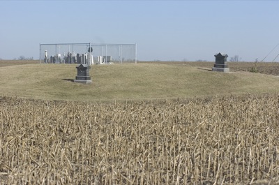
COLDWATER - Local genealogical society members and Butler Township trustees hope to negotiate an agreement on boundaries of the old Burntwood Cemetery with the owner of the land that surrounds it. [More]