CELINA - The county in a rare move is seeking to sell a small tract of land near Grand Lake that includes an abandoned sanitary sewer lift station and drainage tiles.
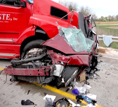
FORT RECOVERY - An area teen was seriously injured late Thursday afternoon when her car collided with a semi on state Route 49, south of the village of Fort Recovery. [More]
CELINA - The American Soybean Association has been working for 90 years to keep U.S. soybean farmers competitive, a former president of the organization says.
CELINA - The Celina boys' tennis team maintained a perfect mark in Western Buckeye League matches with a 5-0 win over Bath on a windy and chilly Thursday afternoon at the Tennis Complex. [More]
Wildkittens score 16 runs during five-inning win over the Green and White
CELINA - It was supposed to be a matchup between Western Buckeye League title contenders on Thursday at Bill Feth Diamond when Celina's softball team hosted Bath.
The Celina track team took home first place in both the boys' and girls' divisions at the inaugural Celina Relays Challenge, taking on local rivals St. Marys and Coldwater.