Special Weather Statement issued April 2 at 8:39AM EDT by NWS Wilmington OH (details ...)
At 839 AM EDT, a strong thunderstorm was located near Union City, moving northeast at 60 mph.
HAZARD...Wind gusts up to 40 mph and half inch hail.
SOURCE...Radar indicated.
IMPACT...Gusty winds could knock down tree limbs and blow around unsecured objects. Hail may cause minor damage to vegetation.
Locations impacted include... New Weston, Fryburg, Chickasaw, New Bremen, Fort Recovery, Botkins, New Knoxville, State Route 47 at US Route 127, Eldora Speedway, Neptune, Fort Loramie, Osgood, Moulton, Coldwater, Sharps Crossing, Kossuth, Lake Loramie State Park, North Dayton, Waynesfield, and Minster.
This includes I-75 in Ohio between mile markers 101 and 118.
If outdoors, consider seeking shelter inside a sturdy building.
To report hazardous weather conditions, go to our website at weather.gov/iln and submit your report via social media, when you can do so safely.
Flood Watch issued April 2 at 3:24AM EDT until April 6 at 8:00AM EDT by NWS Wilmington OH (details ...)
* WHAT...Flooding caused by excessive rainfall continues to be possible.
* WHERE...The following counties, in Indiana, Dearborn, Fayette, Franklin, Ohio, Ripley, Switzerland, Union and Wayne, the following counties, in Kentucky, Boone, Bracken, Campbell, Carroll, Gallatin, Grant, Kenton, Lewis, Mason, Owen, Pendleton and Robertson, and the following counties, in Ohio, Adams, Auglaize, Brown, Butler, Champaign, Clark, Clermont, Clinton, Darke, Delaware, Fairfield, Fayette, Franklin, Greene, Hamilton, Hardin, Highland, Hocking, Licking, Logan, Madison, Mercer, Miami, Montgomery, Pickaway, Pike, Preble, Ross, Scioto, Shelby, Union and Warren.
* WHEN...From this evening through Sunday morning.
* IMPACTS...Soils remain moist and excessive runoff may result in flooding of rivers, creeks, streams, and other low-lying and flood-prone locations.
Wind Advisory issued April 2 at 3:21AM EDT until April 3 at 12:00AM EDT by NWS Wilmington OH (details ...)
* WHAT...South winds 15 to 25 mph with gusts up to 50 mph expected.
* WHERE...Portions of east central and southeast Indiana, northern Kentucky, and southwest and west central Ohio.
* WHEN...From 10 AM this morning to midnight EDT tonight.
* IMPACTS...Gusty winds will blow around unsecured objects. Tree limbs could be blown down and a few power outages may result.
Severe Thunderstorm Warning issued April 2 at 9:10AM EDT until April 2 at 9:45AM EDT by NWS Wilmington OH (details ...)
At 910 AM EDT, a severe thunderstorm was located near New Knoxville, moving northeast at 70 mph.
HAZARD...Quarter size hail.
SOURCE...Radar indicated.
IMPACT...Minor damage to vehicles is possible.
Locations impacted include... Fryburg, Uniopolis, New Bremen, Buckland, Botkins, New Knoxville, Kettlersville, Moulton, St. Marys, State Route 195 at State Route 235, Roundhead, Jumbo, Lake Loramie State Park, Waynesfield, Wapakoneta, Cridersville, St. Johns, Minster, Bulkhead, and Mccartyville.
This includes I-75 in Ohio between mile markers 102 and 118.
Today 74° Today 74° 59° 59° chance Tomorrow 68° Tomorrow 68° chance chance 47° 47°
Monday, February 25th, 2013
Obituaries on February 25th, 2013
Antoinette A. "Toni" Baugher, 91, formerly of Russia, Ohio, died at 11:45 a.m. Feb. 23, 2013, at Dorothy Love Retirement Community, Sidney. [More]
Rita Catherine Homan, 83, of Villa Hills, Ky., formerly of Coldwater, passed peacefully on Feb. 22, 2013, at home with her two daughters at her side. [More]
Vincent E. Gruss, 77, of Coldwater, died Feb. 24, 2013, at The Gardens at Celina. [More]
James A. Adams, 84, St. Marys, died at 9:45 p.m. Feb. 22, 2013, at St. Marys Living Center. [More]
Stories on February 25th, 2013
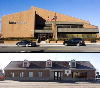
Departments would relocate after $1.9 million purchase
CELINA - City officials intend to purchase the First Financial Bank building across from city hall on Main Street for $1.95 million to relocate all of its departments and offices except the fire department and municipal court. [More]
NEW BREMEN - Little Oliver Dietzman appears to be the picture of health - big hazel eyes, a toothless grin and an inquisitive nature.
But looks are [More]
WAPAKONETA - All non-nursing staff members at Auglaize Acres Nursing Home will receive a four-hour per week cut in hours in the near future.
Servic
Several area fire departments help put out flames
COLDWATER - Fire destroyed a pole barn Sunday afternoon at the home of Larry and Jean Jutte, 4210 state Route 118.
Mercer County Central Dispatch
Division II Sectional at Spencerville
SPENCERVILLE - Sectional titles are nice but Celina's girls basketball team didn't feel the need to celebrate after winning their seventh straight on Saturday night.
Division IV Sectional at Coldwater
COLDWATER - Saturday night's Division IV girls sectional finals doubleheader proved the old adage that revenge is a dish best served cold.
About one year cold, to be exact.
District Wrestling Roundup
Compiled by Gary R. Rasberry
For the first time in three years, Coldwater will be represented at the state wrestling tournament after two Cavaliers advanced out of the Division III district tournament at Trent Arena in Kettering on Sunday.
Local pictures on February 25th, 2013